
Rehoboth Tours & Safaris
Rehoboth Tours and Safaris is a Zimbabwe-registered company with offices in the tourist capital of Victoria Falls, Zimbabwe. The Company specializes in providing services such as Mid-budget to Luxury Safari lodges, Budget Camping, Hwange Safari trips, Chobe full-day trips, Hotel Reservations, packaged tours, Activities, and Airport transfers in Zimbabwe, Botswana, Zambia, South Africa, and Namibia.
TOP
BOTSWANA
ATTRACTIONS
Every day is a Holiday.
Chobe National Park
IUCN category II (national park)
Location Botswana
Nearest city Kasane
Area 11,700 km2
Established 1967
Chobe National Park is Botswana’s first national park, and also the most biologically diverse. Located in the north of the country, it is Botswana’s third largest park, after Central Kalahari Game Reserve and Gemsbok National Park, and has one of the greatest concentrations of game in all of Africa.
History
The original inhabitants of this area were the San bushmen (also known as the Basarwa people in Botswana). They were nomadic hunter-gatherers who were constantly moving from place to place to find food sources, namely fruit, water, and wild animals. Nowadays one can find San paintings inside the rocky hills of the park.
At the beginning of the 20th century, the region that would become Botswana was divided into different land tenure systems. At that time, a major part of the park’s area was classified as crown land. The idea of a national park that would protect the varied local wildlife and promote tourism was first proposed in 1931. The following year, 24,000 km2 (9,300 sq mi) around Chobe district was officially declared a non-hunting area, and this area was expanded to 31,600 km2 (12,200 sq mi) two years later.
In 1943, heavy tsetse infestations occurred throughout the region, delaying the creation of the national park. By 1953, the project received governmental attention again: 21,000 km2 (8,100 sq mi) was suggested to become a game reserve. Chobe Game Reserve was officially created in 1960, though smaller than initially desired. In 1967, the reserve was declared a national park.
At that time there were several industrial settlements in the region, especially at Serondela, where the timber industry proliferated. These settlements were gradually moved out of the park, and it was not until 1975 that the whole protected area was exempt from human activity. Nowadays traces of the prior timber industry are still visible at Serondela. Minor expansions of the park took place in 1980 and 1987.
Geography and ecosystems
The park can be divided into 4 areas, each corresponding to one distinct ecosystem:
The Serondela area (or Chobe riverfront), situated in the extreme Northeast of the park, has as its main geographical features lush floodplains and dense woodland of mahogany, teak and other hardwoods now largely reduced by heavy elephant pressure. The Chobe River, which flows along the Northeast border of the park, is a major watering spot, especially in the dry season (May through October) for large breeding herds of elephants, as well as families of giraffes, sable, and Cape buffalo. The floodplains are the only place in Botswana where the puku antelope can be seen. Birding is also rewarding here. Large numbers of carmine bee-eaters are spotted in season. When in flood, spoonbills, ibis, various species of storks, ducks, and other waterfowl flock to the area. This is likely Chobe’s most visited section, in large part because of its proximity to Victoria Falls. The town of Kasane, situated just downstream, is the most important town of the region and serves as the northern entrance to the park.
The Savuti Marsh seen from space in May 2012
The Savuti Marsh area, 10,878 km2 (4,200 sq mi) large, constitutes the western stretch of the park (50 km (31 mi) north of Mababe Gate). The Savuti Marsh is the relic of a large inland lake whose water supply was cut a long time ago by tectonic movements. Nowadays the marsh is fed by the erratic Savuti Channel, which dries up for long periods, then curiously flows again as a consequence of tectonic activity in the area. It is currently flowing again and in January 2010 reached Savuti Marsh for the first time since 1982. As a result of this variable flow, there are hundreds of dead trees along the channel’s bank. The region is also covered with extensive savannahs and rolling grasslands, which makes wildlife particularly dynamic in this section of the park. During dry seasons, tourists going on a safari often sight rhinoceros (both black and white), warthog, kudu, impala, zebra, wildebeest, and a herd of elephants. During rainy seasons, the rich birdlife of the park, 450 species in the whole park, is well-represented. Pride of lions, hyenas, zebras or more rarely cheetahs are sighted as well. This region is reputed for its annual migration of zebras and predators.
The Linyanti Marsh, located at the northwest corner of the park and to the north of Savuti, is adjacent to the Linyanti River. To the west of this area lies Selinda Reserve and on the northern bank of Kwando River is Namibia’s Nkasa Rupara National Park. Around these two rivers are riverine woodlands, open woodlands as well as lagoons, and the rest of the region mainly consists of flood plains. There are large concentrations of the lion pride, leopard, African wild dog, roan antelope, sable antelope, a hippopotamus pod, and herds of African bush elephants. The rarer red lechwe, sitatunga and a bask of Nile crocodiles also occur in the area. Bird diversity is rich.
Between Linyanti and Savuti Marshes lies a hot and dry hinterland, mainly occupied by the Nogatsaa grass woodland. This section is little known and is a great place for spotting Eland.
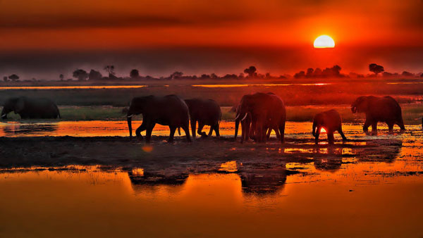
Elephant concentration
The park is widely known for its large elephant population, estimated to be around 50,000. living here are Kalahari elephants, the largest in herd size of all known elephant populations. They are characterized by rather brittle ivory and short tusks, perhaps due to calcium deficiency in the soils. Damage caused by the high numbers of elephants is rife in some areas. The concentration is so high throughout Chobe that culls have been considered but are deemed too controversial and have thus far been rejected by park management. In the dry season, these elephants sojourn in the Chobe River and Linyanti River areas. In the rainy season, they make a 200-kilometer migration to the southeastern stretch of the park. Their distribution zone however outreaches the park and spreads to north-western Zimbabwe.
Roads
Road conditions in Chobe National Park depend greatly on the season and rainfall; one needs a 4×4 vehicle to travel in the park. Thick sand becomes a problem in the Chobe River Front during the dry months, particularly as the temperature rises, while during the wet season, the roads near the river become muddy.
Savuti
Savuti roads, mainly the western Sandridge Road from Mababe Gate, and the roads both north and south of the Savuti channel are typically thick sand and tricky to drive. When rain has fallen, driving along the marsh roads carries the risk of getting stuck, as the wet black cotton soil becomes unnavigable.
Nogatsaa
Nogatsaa roads are waterlogged during the wet months and very little of the road network can be driven at this time. During the dry months, game drives from one pan to the next are on roads with small, thick sandy patches. Once leaving the tar road from Kasane, people would have to drive through thick sand for the first 20 km (12 mi), before reaching a sand road.
Kgalagadi Trans frontier Park
Location Kgalagadi District, Botswana / Northern Cape, South Africa
Nearest city Upington
Area 38,000 km2 (15,000 sq mi)
Established 31 July 1931 (Kalahari Gemsbok National Park)
12 May 2000 (Kgalagadi Transfrontier Park)
Governing body Department of Wildlife and National Parks (Botswana) / South African National Parks
Kgalagadi Transfrontier Park is a large wildlife preserve and conservation area in southern Africa.
The park straddles the border between South Africa and Botswana and comprises two adjoining national parks:
Kalahari Gemsbok National Park in South Africa
Gemsbok National Park in Botswana
The total area of the park is 38,000 square kilometers (15,000 sq mi). Approximately three-quarters of the park lies in Botswana and one-quarter in South Africa. Kgalagadi means “place of thirst.” In December 2015, media reports claimed that rights for gas fracking in more than half of the Botswana portion of the park had been sold. The Botswana government later refuted these reports.
Location and terrain
The park is located largely within the southern Kalahari Desert. The terrain consists of red sand dunes, sparse vegetation, occasional trees, and the dry riverbeds of the Nossob and Auob Rivers. The rivers are said to flow only about once per century. However, water flows underground and provides life for grass and Vachellia erioloba trees growing in the riverbeds. The rivers may flow briefly after large thunderstorms.
Wildlife
The park has abundant, varied wildlife. It is home to large mammalian predators such as lions, cheetahs, African leopards, and hyenas. Migratory herds of large herbivores such as blue wildebeest, springbok, eland, and red hartebeest also live and move seasonally within the park, providing sustenance for the predators. More than 200 species of bird can be found in the park, including vultures and raptors such as eagles, buzzards, and secretary birds.
Since 2005, the protected area is considered a Lion Conservation Unit and a lion stronghold in Southern Africa.
Weather
The weather in the Kalahari can reach extremes. January is midsummer in southern Africa and the daytime temperatures are often in excess of 40 °C (104 °F). Winter nights can be quite cold with temperatures below freezing. Extreme temperatures of −11 °C (12 °F) and up to 45 °C (113 °F) have been recorded. Precipitation is sparse in this desert area.
Facilities
Within the park, there are three traditional tourist lodges, called “rest camps”. These are fully serviced lodges and include amenities such as air conditioning, shops, and swimming pools. There are also six wilderness camps in the park. The wilderness camps provide little more than shelter and wash water; visitors must supply their own food, drinking water, and firewood.
History
The Kalahari Gemsbok National Park in South Africa was established on 31 July 1931 mainly to protect the migrating game, especially the gemsbok, from poaching. In 1948 an informal verbal agreement was made between the then Bechuanaland Protectorate and the Union of South Africa to set up a conservation area in the contiguous areas of the two lands. In June 1992 representatives from the South African National Parks Board (now SANParks) and the Department of Wildlife and National Parks of Botswana set up a joint management committee to manage the area as a single ecological unit. A management plan was drafted, reviewed, and approved in 1997. The parties agreed to cooperate in tourism and share equally in park entrance fees. On 7 April 1999, Botswana and South Africa signed a historic bilateral agreement whereby both countries undertook to manage their adjacent national parks, the Gemsbok National Park in Botswana and the Kalahari Gemsbok National Park in South Africa as a single ecological unit. The boundary between the two parks had no physical barriers, although it is also the international border between the two countries. This allowed for the free movement of animals. On 12 May 2000, President Festus Mogae of Botswana and President Thabo Mbeki of South Africa formally launched Southern Africa’s first peace park, the Kgalagadi Transfrontier Park.
Cultural preservation and establishment of!Xaus Lodge
In October 2002, the governments set aside 580 km² (224 mi²) for the use of the native peoples, the Khomani San and Mier communities. This was divided between 277.69 km² of San Heritage Land and 301.34 km² of Mier Heritage Land. The South African National Parks (SANParks) manages the land under contract. This land was named the!Ae!Hai Heritage Park. The settlement agreement also provided for the communities to receive funds for the specific purpose of constructing a tourism facility. The lodge was named!Xaus Lodge (meaning ‘heart’ in the local language) and is managed commercially on behalf of the ‡Khomani San and Mier communities by Transfrontier Parks Destinations.
! Xaus Lodge’s existence allows the cultural practices of the ‡Khomani San to continue in a few ways. The cultural village near the Lodge allows the local people to create and sell their crafts. This is both a way for them to emulate and remember the culture of historical ‡Khomani San and a way for them to express the changes in that culture. The! Ae! Hai Heritage Park has also been named the first International Dark Sky Sanctuary in Africa by the International Dark Sky Association.
Fracking
In December 2015, it was reported in the media that the government of Botswana quietly sold the rights to frack for shale gas in Kgalagadi Transfrontier Park. Reports said it granted prospecting licenses for 29,291 square kilometers (2,929,100 ha), 34,435 square kilometers (3,443,500 ha), and 23,980 square kilometers (2,398,000 ha) – more than half of the Botswanan part of the park – to a United Kingdom-listed company called “Nodding Donkey”. The sale was not reported at the time. In November 2015, the company changed its name to “Karoo Energy”. In February 2016 Botswana’s Ministry of Environment, Wildlife and Tourism refuted these reports saying “There are also no licenses for fracking in the KTP” and “no intention to issue any approvals for fracking in the KTP or any other national park or national game reserve anywhere in Botswana”.
Makgadikgadi Pan
The main water source is the Nata River, called Amanzanyama in Zimbabwe, where it rises at Sandown about 37 mi (59.5 km) from Bulawayo. A smaller amount of water is supplied by the Boteti River from the Okavango delta.
Geography
Location Okavango Delta
Country Botswana
The Makgadikgadi Pan a salt pan situated in the middle of the dry savanna of north-eastern Botswana, is one of the largest salt flats in the world. The pan is all that remains of the formerly enormous Lake Makgadikgadi, which once covered an area larger than Switzerland, but dried up tens of thousands of years ago. Recent studies of human mitochondrial DNA suggest that modern Homo sapiens first began to evolve in this region some 200,000 years ago when it was a vast, exceptionally fertile area of lakes, rivers, marshes, woodlands, and grasslands especially favourable for habitation by evolving hominins and other mammals.
Location and description
Lying southeast of the Okavango Delta and surrounded by the Kalahari Desert, Makgadikgadi is technically not a single pan, but many pans with sandy desert in between, the largest being the Sua (Sowa), Ntwetwe, and Nxai Pans. The largest individual pan is about 1,900 sq mi (4,921.0 km2). In comparison, Salar de Uyuni in Bolivia is a single salt flat of 4,100 sq mi (10,619.0 km2), rarely has much water, and is generally claimed to be the world’s largest salt pan. A dry, salty, clay crust most of the year, the pans are seasonally covered with water and grass and are then a refuge for birds and animals in this very arid part of the world. The climate is hot and dry, but with regular annual rains.
The main water source is the Nata River, called Amanzanyama in Zimbabwe, where it rises at Sandown about 37 mi (59.5 km) from Bulawayo. A smaller amount of water is supplied by the Boteti River from the Okavango Delta.
These salt pans cover 6,200 sq mi (16,057.9 km2) in the Kalahari Basin and form the bed of the ancient Lake Makgadikgadi, which evaporated many millennia ago. Archaeological recovery in the Makgadikgadi Pan has revealed the presence of prehistoric man through abundant finds of stone tools; some of these tools have been dated sufficiently early to establish their origin as earlier than the era of Homo sapiens. Pastoralists herded grazing livestock here when water was more plentiful earlier in the Holocene.
The lowest place in the basin is Sua Pan with an elevation of 2,920 feet.
Geology
Victoria Falls share geology with Makgadikgadi and Kalahari
As the ancestral Lake Makgadikgadi shrank, it left relic shorelines, which are most evident in the southwestern part of the basin.[5] As the lake shrank numerous smaller lakes formed with progressively smaller shorelines. The relic shorelines at elevations of 3100 feet and 3018 feet can be seen most easily on Gidikwe Ridge, west of the Boteti River.
The geologic processes behind the formation of the basin are not well understood. It is conjectured that there was a gentle down-warping of the crust, with accompanying mild tectonics and associated faulting; however, no significant plate boundary faults have been identified. The main axis of the developing graben runs northeast southwest.
Kubu Island and Kukome Island are igneous rock “islands” in the salt flat of Sua pan. Kubu Island lies in the southwestern quadrant of Sua Pan, contains a number of baobab trees, and is protected as a national monument.
Flora
Baobab in the Makgadikgadi Pan’s National Park
The pans themselves are salty deserts whose only plant life is a thin layer of blue-green algae. However, the fringes of the pan are salt marshes and further out these are circled by grassland and then shrubby savanna. The prominent baobab trees found in the area function as local landmarks. One of them, named after James Chapman, served as an unofficial post office for 19th-century explorers.
Fauna
Flamingo migration at the Makgadikgadi Pan
Very little wildlife can exist here during the harsh dry season of strong hot winds and only salt water, but following a rain, the pan becomes an important habitat for migrating animals including wildebeest and one of Africa’s biggest zebra populations, and the large predators that prey on them. The wet season also brings migratory birds such as ducks, geese, and great white pelicans. The pan is home to one of only two breeding populations of greater flamingos in southern Africa, and only on the Soa pan, which is part of the Makgadikgadi pans. The other breeding population is at Etosha, in the Northern part of Namibia. The only birds here in the dry season are ostriches, chestnut-banded plover (Charadrius pallidus), and Kittlitz’s plover (Charadrius pecuarius). The grasslands on the fringes of the pan are home to reptiles such as tortoises, rock monitors (Varanus albigularis), snakes, and lizards including the endemic Makgadikgadi spiny agama (Agama hispida makgadikgadiensis). The region’s salt water is home to the cladoceran crustacean Moina belli.
Threats and preservation
The salt pans are very inhospitable and human intervention has been minimal, so they remain fairly undisturbed, although land surrounding the pans is used for grazing and some areas have been fenced off, preventing the migration of wildlife. Modern commercial operations to extract salt and soda ash began on Sua Pan in 1991, and there are also plans to divert water from the Nata River for irrigation, which would cause severe damage to the salt pan ecosystem. Another threat is the use of quad bikes and off-road vehicles by tourists, which disturbs breeding colonies of flamingos. Illegal hunting in national parks is a persistent problem.
There are some protected areas within the Makgadikgadi and Nxai Pan National Park. The Makgadikgadi Pans Game Reserve is the scene of large migrations of zebra and wildebeest from the Boteti River across to Ntwetwe Pan, while the Nata Sanctuary in Sua Pan is a place to see birdlife and antelopes. In Nxai Pan the baobabs painted by 19th-century British artist Thomas Baines are still visible. The area can be accessed between the towns of Nata and Maun, or from the town of Gweta.
The main water source is the Nata River, called Amanzanyama in Zimbabwe, where it rises at Sandown about 37 mi (59.5 km) from Bulawayo. A smaller amount of water is supplied by the Boteti River from the Okavango delta.
Moremi Game Reserve
Moremi Game Reserve is a protected area in Botswana. It lies on the eastern side of the Okavango Delta and was named after Chief Moremi of the BaTawana tribe. Moremi was designated as a game reserve, rather than a national park, when it was created. This designation meant that the BaSarwa or Bushmen that lived there were allowed to stay in the reserve.
Location and setting
Moremi Game Reserve is just under 5,000 square kilometres (1,900 sq mi) in extent, covering much of the eastern side of the Okavango Delta and combining permanent water with drier areas, which create some startling and unexpected contrasts. Some prominent geographical features of the Reserve are Chiefs Island and the Moremi Tongue.[1] In the Moremi Reserve one can experience excellent views of savannah game as well as bird-watching on the lagoons. There are also thickly wooded areas, which are home to the Cape wild dog (Lycaon pictus pictus) and leopard. To the northeast lies the Chobe National Park which borders the Moremi Game Reserve. Only about 30% of the reserve is mainland, with the bulk being within the Okavango Delta itself.
Fauna and flora
Moremi Game Reserve, although not one of the largest parks, presents insights and views even for the most experienced of travellers. Its habitats are surprisingly diverse, combining mopane woodland and acacia forests, floodplains and lagoons. It is home to nearly 500 species of bird (from water birds to forest dwellers), and a vast array of other species of wildlife including lion, leopard, African bush elephant, African buffalo, black rhinoceros, hippopotamus, giraffe, plains zebra, blue wildebeest, cheetah, spotted hyena, black-backed jackal, common warthog, impala, and lechwe. The Moremi area is considered a significant habitat for African wild dog and the population there have been the subject of a project run in the area since 1989; thus, this species is often seen wearing collars emplaced by researchers.
History
Proclaimed a reserve in 1963, it was named after Chief Moremi III of the local Batawana tribe from Ngamiland. Chief Moremi’s widow, Elizabeth Pulane Moremi, – who was ruling the area at the time, took steps to conserve the wildlife due to her concern about the toll hunting was taking on the animal population. In the 1970s Chief Moremi’s Royal Hunting Grounds were included into the Reserve to further expand it.
Logistics
The Reserve offers the opportunity to explore not only in 4×4’s but on foot and by mokoro – a dug-out canoe, hewn from either ebony or sausage-tree, and poled by your personal guide. Although, today most of the mekoro (plural of mokoro), are made from fibreglass, thus helping to preserve the magnificent, and old, trees of the area.
Game viewing is at its peak from July to October, when seasonal pans dry up and the wildlife concentrates on the permanent water. From October until the start of the rains in late November or early December, the weather can be extremely hot.
Malarial mosquitoes are prevalent throughout the Reserve and it is strongly recommended that visitors should take precautions before, during and after a visit.
Botswana has been able to develop its tourism without the urgent need for revenues that face many other African countries. An eco-tourism policy of high yield, but low impact, has resulted in visitors being able to experience an Africa in its most natural, unspoilt and impressive condition. Thus, the Reserve itself has very few lodges, and only four areas set-aside for camping (at South Gate, Third Bridge, Xakanaxa, and Khwai). There are a number of lodges on the outskirts of the Reserve, whose guests visit on daily game drives.
Travel between lodges is accomplished by light aircraft and helicopter transfers, as most lodges have their own airstrips. Therefore, you can easily combine a number of lodges in a variety of areas. Helicopter game viewing flights are available from most lodges.
Roads
Roads in Moremi Game Reserve change dramatically depending upon the season and the water level of the Delta. When the flood waters are high some of the roads are waterlogged while sandy areas which are much harder to navigate during the hot summer months. Moremi Game Reserve is a low impact park, which means that there are few vehicles and people around. This is great for game viewing as you are often alone at a sighting, but it also means that help isn’t readily available away from the main roads. Ensure you have a sufficient recovery kit and know how to use it, and you’ll need a snorkel on your vehicle for water crossings. If you are driving a rental vehicle, double check the rental company’s rules and regulation regarding driving through water.
Poaching
Starting April 2019, poaching has risen at an alarming rate in the reserve. Organised poaching rings slaughtered 46 rhinos in 10 months, representing almost 10% of Botswana’s 500 rhinos. Officials feared a wipe-out of both rhino species, as most of Botswana’s rhinos roam the grassy plains of the northern Okavango Delta, where Moremi Game Reserve is situated. The poaching is driven by the insatiable demand for rhino horn, which fetches up to $60,000 / kg.
Nxai Pan National Park
IUCN category Ib (wilderness area)
Location Botswana
Area 2578 km²
Established 1992
Nxai Pan National Park is a national park in north-eastern Botswana, consisting of Nxai Pan, which is one of the Makgadikgadi Pan salt flats. Nxai Pan National Park lies just north of the Maun-Nata main road and adjoins Makgadikgadi Pans National Park on its northern border. The pan itself is a fossil lakebed about 40 square km in size.
The National Park is also home to the cluster of millennia-old baobab trees, which owe their name to Thomas Baines, the man known to have discovered them. Baines’ Baobabs, as they are known today, are a sight sought by many travelers venturing into this untamed terrain of Botswana.
Wildlife
Ostrich and springbok at a waterhole in the park
This national park is home to elephant, giraffe, zebra, wildebeest, lion, leopard, cheetah, kudu, springbok, impala, ostrich, Cape wild dog, jackal, hyena, bat-eared fox, aardwolf, and honey badger.
Conservation
This park is considered for inclusion in the 5 Nation Kavango – Zambezi Trans frontier Conservation Area.
Roads
The rainy season which is from November to April is the hot wet summer season and the time when the park is at its best. Game is abundant from December to April but if the rains have been heavy the roads may be difficult to negotiate. Road conditions can become difficult during times of heavy rains. The more accessible time to be in the park is in the dry season, which is from May to September.
Okavango Delta
UNESCO World Heritage Site
Location Botswana
Area 2,023,590 ha
Buffer zone 2,286,630 ha
Ramsar Wetland
Official name Okavango Delta System
Designated 12 September 1996
The typical region in the Okavango Delta, with free canals and lakes, swamps and islands
The Okavango Delta (or Okavango Grassland) (formerly spelled “Okovango” or “Okovanggo”) in Botswana is a swampy inland delta formed where the Okavango River reaches a tectonic trough at an altitude of 930–1,000 m in the central part of the endorheic basin of the Kalahari. All the water reaching the delta is ultimately evaporated and transpired and does not flow into any sea or ocean. Each year, about 11 cubic kilometers (2.6 cu mi) of water spread over the 6,000–15,000 km2 (2,300–5,800 sq mi) area. Some floodwaters drain into Lake Ngami.[4] The area was once part of Lake Makgadikgadi, an ancient lake that had mostly dried up by the early Holocene.
The Moremi Game Reserve, a National Park, is on the eastern side of the delta. The delta was named one of the Seven Natural Wonders of Africa, which was officially declared on 11 February 2013 in Arusha, Tanzania. On 22 June 2014, the Okavango Delta became the 1000th site to be officially inscribed on the UNESCO World Heritage List.
Geography
Floods
The Okavango is produced by seasonal flooding. The Okavango River drains the summer (January–February) rainfall from the Angola highlands and the surge flows 1,200 km (750 mi) in around one month. The waters then spread over the 250 by 150 km (155 by 93 mi) area of the delta over the next four months (March–June). The high temperature of the delta causes rapid transpiration and evaporation, resulting in 3 cycles of rising and falling water level that was not fully understood until the early 20th century. The flood peaks between June and August, during Botswana’s dry winter months, when the delta swells to three times its permanent size, attracting animals from kilometers around and creating one of Africa’s greatest concentrations of wildlife.
The delta is very flat, with less than 2 m (6 ft 7 in) variation in height across its 15,000 km2 (5,800 sq mi), while the water drops about 60 m from Mohembo to Maun.


VIEW TOURS AND SAFARIS
Botswana is a landlocked country in Southern Africa. Botswana is topographically flat, with up to 70 percent of its territory being the Kalahari Desert. It is bordered by South Africa to the south and southeast, Namibia to the west and north, and Zimbabwe to the northeast. It is connected to Zambia across the short Zambezi River border by the Kazungula Bridge.