
Rehoboth Tours & Safaris
Rehoboth Tours and Safaris is a Zimbabwe-registered company with offices in the tourist capital of Victoria Falls, Zimbabwe. The Company specializes in providing services such as Mid-budget to Luxury Safari lodges, Budget Camping, Hwange Safari trips, Chobe full-day trips, Hotel Reservations, packaged tours, Activities, and Airport transfers in Zimbabwe, Botswana, Zambia, South Africa, and Namibia.
TOP
NAMIBIA
DESTINATIONS
Every day is a Holiday.
At 824,292 km 2 (318,261 sq mi), Namibia is the world’s thirty-fourth largest country. After Mongolia, Namibia is the second least densely populated country in the world (2.7 inhabitants per square kilometer (7.0/sq mi)). Namibia got its name from the Namib desert that stretches along the coast of the Atlantic. It is also known for its wildlife. Namibia attractions
Etosha National Park
Location Namibia
Area 22,270 km2
Established March 22, 1907
Governing body Ministry of Environment and Tourism, Namibia
Etosha National Park is a national park in north-western Namibia and one of the largest national parks in Africa. It was proclaimed a game reserve in March 1907 in Ordinance 88 by the Governor of German Southwest Africa, Friedrich von Lindequist. It was designated as Wildschutzgebiet in 1958 and was elevated to the status of a national park in 1967 by an act of parliament of the Republic of South Africa. It spans an area of 22,270 km2 (8,600 sq mi) and gets its name from the large Etosha pan which is almost entirely within the park. With an area of 4,760 km2 (1,840 sq mi), the Etosha pan covers 23% of the total area of the national park. The area is home to hundreds of species of mammals, birds and reptiles, including several threatened and endangered species such as the black rhinoceros.
The park is located in the Kunene region and shares boundaries with the regions of Oshana, Oshikoto and Otjozondjupa.
Fish River Canyon
Area 5,900 km2
Governing body Ministry of Environment and Tourism
The Fish River Canyon (Afrikaans: Visrivier Canyon or Visrivier Kuil, German: Fischfluss Canyon), is located in the south of Namibia. It is the largest canyon in Africa, as well as the second most visited tourist attraction in Namibia. It features a gigantic ravine, in total about 160 kilometres (100 mi) long, up to 27 km wide and in places almost 550 meters deep.
The Fish River is the longest interior river in Namibia. It cuts deep into the plateau which is today dry, stony and sparsely covered with hardy drought-resistant plants. The river flows intermittently, usually flooding in late summer; the rest of the year it becomes a chain of long narrow pools. At the lower end of the Fish River Canyon, the hot springs resort of ǀAi-ǀAis is situated.
Public view points are near Hobas, a camp site 70 km north of ǀAi-ǀAis. This part of the canyon is part of the ǀAi-ǀAis/Richtersveld Transfrontier Park. The other 90 km of this canyon are privately owned.
Geology
The Fish River canyon consists of an upper canyon, where river erosion was inhibited by hard gneiss bedrocks, and a lower canyon formed after erosion had finally worn through the gneisses. Both parts have been declared a national monument in 1962
Upstream, the river runs through horizontal dolomite strata; these metamorphic rocks formed part of the canyon. About 650 million years ago (Mya), plate movement formed a north-south graben, or lowered area, along which the ancient Fish River could flow and eventually erode a flat plain, which is today’s upper canyon. Glaciation at around 300 Mya, part of the Dyka glaciation during the Karoo Ice Age, further deepened the canyon. About 60 Mya, South America and Africa separated (due to continental drift) and Africa rose significantly; the consequentially increased gradient of the Fish River enabled it to erode the lower canyon into the hard gneisses, forming the current deeply twisting, meandering system of the lower canyon. With the separation of the continent Gondwana about 120 million years ago and the uplifting of the African continent the gradient of the Fish River increased allowing it to erode even deeper into the rock. Today the deepest point of the canyon is 549 metres deep.
The Fish River Canyon Hiking Trail
Wild Fig Bend 27.638°S 17.599°E
Length 90 km [5]
Location Fish River Canyon
Trailheads Hobas / ǀAi-ǀAis
Use Hiking / Trail running
Elevation gain/loss 620 m (Loss)
Highest point 840 m
Lowest point 220 m
Difficulty Medium
Season Winter in Southern Hemisphere
Months 1 May – 16 Sep
Sights Spectacular scenery, wildlife
Hazards Steep descent, boulders, rocks, deep sand, slippery river crossings, baboons, snakes, scorpions
The Fish River Canyon hiking trail is one of the more popular hiking trails in Southern Africa. The immense scale and rugged terrain have drawn many visitors from all over the world to experience what hiking or trail running the canyon can offer.
Apart from the 2-kilometre descent west of Hobas and some optional short cuts, the trail generally follows 88 kilometres of the Fish River through to ǀAi-ǀAis and is usually completed within 5 days.Although there are a number of footpaths through the canyon, the trail is not fixed leaving the hiker to decide where and how long to hike.
There are no amenities on the trail and hikers have to carry all their needs with them. Open fires are not allowed on the trail.
In times of inclement weather, some shelter in a run-down building can be found at the Causeway (27.829°S 17.571°E) but otherwise sleeping is outdoors.
The weather is usually mild and typical temperatures vary between 5 °C and 30 °C with little humidity. Extreme weather, such as flash floods, stormy winds and rain occasionally play havoc during the hiking season.
Permits
Due to flooding and extremely hot summer temperatures reaching 48 °C in the day and 30 °C at night, permits are only issued between 1 May and 15 September.
Prior to arriving at Hobas a hiking permit must be obtained from Namibia Wildlife Resorts for groups not smaller than 3 and not larger than 30. All hikers must be older than 12 years and a certificate of fitness, completed by a medical doctor, must be presented at the offices of the Ministry of Environment and Tourism at Hobas.
In recent years the trail has become popular, particularly during school holidays and long weekends, and permits should be requested well in advance. Bookings for the following year’s season open 1 May.
Trailhead campgrounds
Hobas (27.619°S 17.715°E) houses the Ministry of Environment and Tourism offices as well as Namibia Wildlife Resorts offices and a little shop for curiosities and basic necessities. Camping underneath Camelthorn trees with ablution blocks is available for hikers who plan to overnight at Hobas.
ǀAi-ǀAis/Richtersveld Transfrontier Park
Location ǁKaras Region
Nearest city Rosh Pinah, Namibia
Alexander Bay, South Africa
Area 6,045 km2
Established 2003
Named for ǀAi-ǀAis Hot Springs
Richtersveld
Governing body Ministry of Environment and Tourism (Namibia)
South African National Parks
The ǀAi-ǀAis/Richtersveld Transfrontier Park is a peace park straddling the border between South Africa and Namibia. It was formed in 2003 by combining the Namibian ǀAi-ǀAis Hot Springs Game Park and the South African Richtersveld National Park. Most of the South African part of the park forms part of the buffer zone of the Richtersveld Cultural and Botanical Landscape World Heritage Site, which measures 5,920 square kilometres (2,290 sq mi).The Fish River Canyon is located in the park, the largest canyon in Africa. A memorandum of understanding was signed on 17 August 2003 by the presidents of South Africa and Namibia, which formalized the establishment of the park. |Ai-|Ais means ‘burning water’, after the hot springs of the same name.
The Sendelingsdrift tourist facilities were opened in 2007 to enable tourists and locals to travel between Namibia and South Africa within the boundaries of the park. Immigration offices were set up on both sides of the Orange River. It is also known for being a biodiversity hotspot, which means it is under constant threat from human encroachment.
Nama people
The Nama people can still be found in the region. Known for begin nomadic pastoralists, their way of life is suited for the arid region. Herders and their livestock can be seen moving over long distances, as they try to anticipate the much needed yet sparse rainfall. The Nama language has also been preserved here by the Nama communities more than any other place in the Namaqualand region.
Climate
The |Ai-|Ais/Richtersveld has two major climatic systems. It has a temperate winter rainfall region that also contains high air humidity, contrasted by the high temperature with its summer rains yet low humidity further inland. These contrasting climates have a transitional zone of about 20 kilometres (12 mi).
Landscape
The general area consists of rugged valleys and high mountains. The land is harsh, while water is generally scarce, the air is kept moist by early morning fog. The Nama locals call the fog that comes in from the Atlantic Ocean ‘Ihuries’ or ‘Malmokkies’. The park is regarded as a unique mega-ecosystem in the world. In a one square kilometer area more than 360 different plant species can be found in a place that experiences an average rainfall of only 68 mm per year.[4] The vegetation in |Ai-|Ais/Richtersveld Transfrontier Park consists of unique plant life, such as the bastard quiver tree, ‘half-mens’ (Afrikaans: half human), and tall aloes. The half-mens is typified by an unbranched, cylindrical stem, which can reach heights of up to 4m. The top has a tuft of branches. The local Nama community hold the half-mens tree in high regard, believing that the human-like figure it assumes is their ancestors longing for the Namibian home.
Kolmanskop
Location in Namibia
Country Namibia
Region ǁKaras Region
Kolmanskop (Afrikaans for “Coleman’s head”, German: Kolmannskuppe) is a ghost town in Namib in southern Namibia, ten kilometers inland from the port town of Lüderitz. It was named after a transport driver named Johnny Coleman who, during a sand storm, abandoned his ox wagon on a small incline opposite the settlement.[1] Once a small but very rich mining village, it is now a tourist destination run by the joint firm Namibia-De Beers.
History
Foundation and peak
In 1908, in what was then German South-West Africa, the worker Zacharias Lewala found a diamond while working in this area and showed it to his supervisor, the German railway inspector August Stauch. Realizing the area was rich in diamonds, German miners began the settlement, and soon after the German Empire declared a large area as a “Sperrgebiet”, starting to exploit the diamond field.
Driven by the enormous wealth of the first diamond miners, the residents built the village in the architectural style of a German town, with amenities and institutions including a hospital, ballroom, power station, school, skittle alley, theatre, and sport-hall, casino, ice factory and the first x-ray-station in the southern hemisphere, as well as the first tram in Africa. It had a railway link to Lüderitz.
Decline
The town started to decline during World War I when the diamond field slowly started to deplete. By the early 1920s, the area was in a severe decline. Hastening the town’s demise was the discovery in 1928 of the richest diamond-bearing deposits ever known, on the beach terraces 270 km south of Kolmanskop, near the Orange River. Many of the town’s inhabitants joined the rush to the south, leaving their homes and possessions behind. The new diamond finds merely required scouting the beaches as opposed to more difficult mining. The town was ultimately abandoned in 1956. The geological forces of the desert mean that tourists now walk-through houses knee-deep in sand. Kolmanskop is popular with photographers for its settings of the desert sands’ reclaiming this once-thriving town, and the arid climate preserving the traditional Edwardian architecture in the area. Due to its location within the restricted area (Sperrgebiet) of the Namib desert, tourists need a permit to enter the town.
In popular culture
Kolmanskop was featured on the series Mysteries of the Abandoned episode entitled “Animal Uprising”, that first aired October 18, 2020 on the Animal Planet Channel.
Kolmanskop was used as the location for the South African TV movie The Mantis Project (1987). Directed by Manie van Rensburg, produced by Paul Kemp, written by John Cundill, and starred Marius Weyers and Sandra Prinsloo.
The town was used as one of the locations in the 1993 film Dust Devil.
The 2000 film The King Is Alive was filmed in Kolmanskop, with the town used as the film’s main setting.
The town was featured in a 2010 episode of Life After People. The episode focused on the effects of wind and sand on the various run-down buildings and displayed rooms that were filled with sand.
The town was used as one of the locations in the 1994 film Lunarcop.
The town was used in the first episode of the BBC series Wonders of the Universe to help explain entropy and its effect on time.
The television series Destination Truth in one of its episodes investigated Kolmanskop, rumored to be haunted.
Tim Walker photographed Agyness Deyn in Kolmanskop, Namibia for Vogue UK in May 2011.
The 2011 non-narrative film Samsara features shots filmed in Kolmanskop.
Featured in 2011 on Season 1, Episode 2 Namibia/Bodie of the television show Forgotten Planet.
The cover of Tame Impala’s fourth album, The Slow Rush, and its singles were photographed at Kolmanskop by Neil Krug.
The music video for George Watsky’s Undermine from the Placement album was filmed in Kolmanskop.
Lüderitz
Motto(s): Challenge, Innovation, Prosperity
Location in Namibia
Country Namibia
Region ǁKaras Region
Constituency ǃNamiǂNûs Constituency
Established 1883
Population (2011)
- Total 12,537
Time zone UTC+2 (SAST)
Lüderitz is a town in the ǁKaras Region of southern Namibia. It lies on one of the least hospitable coasts in Africa. It is a port developed around Robert Harbour and Shark Island.
The town is known for its colonial architecture, including some Art Nouveau work, and for wildlife including seals, penguins, flamingos and ostriches. It is also home to a museum and lies at the end of a currently decommissioned railway line to Keetmanshoop. The town is named after Adolf Lüderitz, founder of the German South West Africa colony.
Economy and infrastructure
The centre of Lüderitz’ economic activity is the port, until the incorporation of the exclave Walvis Bay in 1994 the only suitable harbour on Namibia’s coast. However, the harbour at Lüderitz has a comparatively shallow rock bottom, making it unusable for many modern ships. The recent addition of a new quay has allowed larger fishing vessels to dock at Lüderitz. The town has also re-styled itself in an attempt to lure tourists to the area, which includes a new waterfront area for shops and offices.
Lüderitz is situated on the B4 national road to Keetmanshoop. It is also the terminus of the 318 kilometres (198 mi) railway line to Seeheim where the railway connects to the rest of the country’s network. This line, built by inmates of the concentration camp on Shark Island, was completed in 1908[5] but is currently not operational. The rebuilding of the remaining 47 kilometres (29 mi) of track gap to Aus has been delayed since 2009.
Construction of a new port at Shearwater Bay, 30 kilometres (19 miles) south of Lüderitz, has been proposed for the export of coal from Botswana with a 1,600-kilometre (990-mile) railway connecting the two.
History
German Protectorate Medal Lüderitz Territory 7 August 1884, reverse
The bay on which Lüderitz is situated was first known to Europeans when Bartolomeu Dias encountered it in 1487. He named the bay Angra Pequena (Portuguese: Small Bay) and erected a padrão (stone cross) on the southern peninsula. In the 18th century Dutch adventurers and scientists explored the area in search of minerals but did not have much success. Further exploration expeditions followed in the early 19th century during which the vast wildlife in the ocean was discovered. Profitable enterprises were set up, including whaling, seal hunting, fishing and guano-harvesting. Lüderitz thus began its life as a trading post.
The town was founded in 1883 when Heinrich Vogelsang purchased Angra Pequena and some of the surrounding land on behalf of Adolf Lüderitz, a Hanseat from Bremen in Germany, from the local Nama chief Josef Frederiks II in Bethanie. On 7 August 1884, the German Flag was officially hoisted in Angra Pequena. When Adolf Lüderitz did not return from an expedition to the Orange River in 1886, Angra Pequena was named Lüderitzbucht in his honour. In 1905, German authorities established a concentration camp on Shark Island. The camp, access to which was very restricted, operated between 1905 and 1907 during the Herero Wars. Between 1,000 and 3,000 Africans from the Herero and Nama tribes died here as a result of the tragic conditions of forced labour. Their labour was used for the expansion of the city, railway, port and on farms of white settlers.
In 1909, after the discovery of diamonds nearby, Lüderitz enjoyed a sudden surge of prosperity due to the development of a diamond rush to the area. In 1912 Lüderitz already had 1,100 inhabitants, not counting the indigenous population. Although situated in a harsh environment between the desert and Ocean, trade in the harbour town surged, and the adjacent diamond mining settlement of Kolmanskop was built.
After the German World War I capitulation, South Africa took over the administration of German South West Africa in 1915. Many Germans were deported from Lüderitz, contributing to its shrinking population numbers. From 1920 onwards, diamond mining was only conducted further south of town in places like Pomona and Elizabeth Bay. This development consequently led to the loss of Lüderitz’s importance as a trading place. Only small fishing enterprises, minimal dock activity and a few carpet weavers remained.
In an effort to remove colonial names from the maps of Namibia, on 8 August 2013 the Namibian government renamed the constituency ǃNamiǂNûs, its name prior to 1884.
Geography
Ghost town Kolmanskop
Just outside Lüderitz lies the ghost town of Kolmanskop, a prominent tourist destination. This previously bustling diamond town is now abandoned and fights a constant struggle against being buried under the shifting sand dunes of the Namib desert.
Conservation
Haviside’s dolphin off Lüderitz
The coastline in the area is recognised by BirdLife and other global conservation groups as one of the Important Bird Areas (IBAs) for important coastal seabird breeding.
In April 2009, an oil spill from an oil tanker risked hundreds of African penguins and other flora and fauna.
Several species of cetaceans, most notably Haviside’s dolphins, can be seen close to the shore while larger whales such as southern right, humpback, minke, fin, and pygmy right, are less common but gradually increasing in numbers.
Climate
Lüderitz has a desert climate (BWk, according to the Köppen climate classification), with moderate temperatures throughout the year. The average annual precipitation is 17 millimetres (0.67 inches). Windy and cold conditions can occur due to the cold South Atlantic current on the coast.
Sesriem
Country Namibia
Region Hardap Region
Time zone UTC+2 (South African Standard Time)
Sesriem is a small settlement in the Namib Desert, in the Hardap Region of Namibia, close to the southern end of the Naukluft Mountains. It is especially known because the “Sesriem gate” is the main access point to the Namib-Naukluft National Park for visitors entering the park to visit the nearby tourist attraction of Sossusvlei. Like many “settlements” in Namib, Sesriem is essentially a filling station with basic services such as public telephones and a couple of small kiosks where travellers can get general supplies such as food and water. In the surroundings of Sesriem, there are several accommodations, such as a few lodges (e.g., “Le Mirage Desert” and the “Sossusvlei Lodge”) and 24 campsites.
By the Sesriem gate, hot air balloons depart in the early morning, providing scenic flights over the Sossusvlei dunes.
Sesriem Canyon
Sesriem is also known for Sesriem Canyon, about 4 km from Sesriem itself, which is the second most important tourist attraction in the area after Sossusvlei. It is a natural canyon carved by the Tsauchab river in the local sedimentary rock, about one kilometre (5⁄8 mi) long and up to 30 metres (100 ft) deep. The name Sesriem is Afrikaans and means “six rawhide thongs”, given by settlers on the Dorsland Trek who had to join six such thongs in order for a bucket to reach the water. Sesriem Canyon is only two metres (6.5 feet) wide in some places and has a portion that permanently contains water, which many animals use.
Solitaire, Namibia
Region Khomas Region
Constituency Windhoek Rural Constituency
Time zone UTC+2 (South African Standard Time)
General dealer
Solitaire is a small settlement in the Khomas Region of central Namibia near the Namib-Naukluft National Park. It currently features the only gasoline station, bakery, cafe, and the only general dealer between the dunes at Sossusvlei and the coast at Walvis Bay, as well as to the capital Windhoek. Solitaire belongs to the Windhoek Rural electoral constituency.
Solitaire is known in The Netherlands because of the book of the same name by Dutch author Ton van der Lee dealing with his stay in this place.
History
In 1948 Willem Christoffel van Coller bought 33,000 hectares of land from the South West Administration (the government of Namibia at the time) for the purpose of farming Karakul sheep. The land was previously an undeveloped area called Areb situated between the Ababis region to the South and the Koireb region to the North.
The area was named Solitaire by Elsie Sophia van Coller (wife of Willem Christoffel van Coller). The name was chosen because of two meanings. Solitaire can mean a single set diamond and Solitaire can also mean solitude or loneliness. Combined these two meanings create the definition of being unique or one-of-a-kind and a precious but solitary place.
The first man-made structure on the Solitaire farm was a 2-room cottage constructed by Mr. Van Coller who also later constructed the main farmhouse, a stone kraal adjacent to the farmhouse, and a dam wall across the river bed. Later he was also responsible for constructing the current shop and installing the first petrol pump. The shop also acted as the regional post office where weekly postbags were delivered. In 1948, the construction of a small chapel was started; it was completed in 1951. The small Dutch-Reformed church is still in use by the local congregation. The church building is also used as a community meeting place, holding Farmer’s Union meetings, elections, and health clinics. In 1968 the farm ‘Solitaire’ was sold to Mr. Maritz and has since gone through numerous owners. The two farms that makeup Solitaire, the businesses, and other area land holdings, are now part of the 45,000-acre Solitaire Land Trust, which is focused on habitat preservation. This semi-arid region, frequented by drought, is home to healthy populations of wildlife, including the endemic Hartmann’s mountain zebra. Farm Solitaire starts at the Great African Escarpment, an important watershed, and includes grasslands, gravel plains, and ephemeral rivers and stretches to the edge of the Namib, one of the oldest deserts in the world.
Sossusvlei
Sossusvlei (sometimes written Sossus Vlei) is a salt and clay pan surrounded by high red dunes, located in the southern part of the Namib Desert, in the Namib-Naukluft National Park of Namibia. The name “Sossusvlei” is often used in an extended meaning to refer to the surrounding area (including other neighboring vleis such as Deadvlei and other high dunes), which is one of the major visitor attractions of Namibia.
The name “Sossusvlei” is of mixed origin and roughly means “dead-end marsh”. Vlei is the Afrikaans word for “marsh”, while “sossus” is Nama for “no return” or “dead end”. Sossusvlei owes this name to the fact that it is an endorheic drainage basin (i.e., a drainage basin without outflows) for the ephemeral Tsauchab River.
Environment
The Sossusvlei area. The Sossusvlei pan proper is the flat ellipse in a lighter shade of colour seen behind the dune in the foreground (mostly on its right)
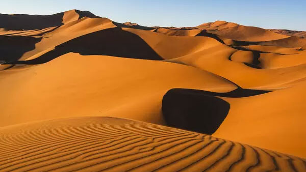
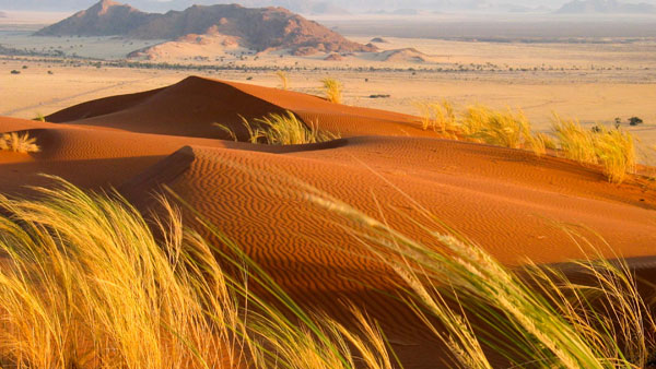
The Sossusvlei area belongs to a wider region of southern Namib with homogeneous features (about 32.000 km²) extending between rivers Koichab and Kuiseb. This area is characterized by high dunes of vivid pink-to-orange colour, an indication of a high concentration of iron in the sand and consequent oxidation processes. The oldest dunes are those of a more intense reddish colour. These dunes are among the highest in the world; many of them are above 200 meters the highest being the one nicknamed Big Daddy, about 325 meters high, however, the highest dune in the Namib Desert, Dune 7, is about 388 meters high.
Traces in the sand, left by insects and other small animals
The highest and more stable dunes are partially covered with relatively rich vegetation, which is mainly watered by several underground and ephemeral rivers that seasonally flood the pans, creating marshes that are locally known as vlei; when dry, these pans look almost white in colour, due to the high concentration of salt. Another relevant source of water for Sossusvlei is the humidity brought by the daily morning fogs that enter the desert from the Atlantic Ocean.
Fauna in the Sossusvlei area is relatively rich. It mostly comprises small animals that can survive with little water, including several arthropods, small reptiles, and small mammalians such as rodents or jackals); bigger animals include antelopes (mainly oryxes and springboks) and ostriches. During the flood season, several migrant bird species appear along the marshes and rivers. Much of the Sossusvlei and Namib fauna is endemic and highly adapted to the specific features of the Namib. Most notably, fog beetles such as the Namib Desert Beetle have developed a technique for collecting water from early morning fog through the bumps in their back.
Climate
The Etosha National Park has a savanna desert climate. The annual mean average temperature is 24 °C. In winter, the mean night-time lows are around 10 °C, while in summer temperatures often hover around 40 °C. As it is a desert, there is a large variation between day and night. Rain rarely falls in the winter.
Sesriem
Access to the Sossusvlei area of the Namib-Naukluft National Park is from the Sesriem gate, which is located in the surroundings of the eponymous canyon. From Sesriem, a 60 km tarmac road leads to Sossusvlei proper.
Elim Dune
The Elim Dune is a high and relatively isolated dune located 5 km past the Sesriem gate, on a branch of the main road connecting Sesriem to Sossusvlei. The dune takes its name from a farm that used to be in the area before the National Park was established.
Dune 45
Dune 45 is so-called because it lies 45 km past Sesriem on the road to Sossusvlei. It is 80 meters high and it is composed of 5-million-year-old sands.
Sossusvlei is about 66 km past the Sesriem gate. The last 6 km can only be traversed with 4WD vehicles as the metalled road ends and sand begins (the place where the metalled road ends is known as “2×4 parking” as any non-4WD vehicle must stop there). Sossusvlei is a clay pan, of roughly elliptical shape, covered in a crust of salt-rich sand.[1] While the pan has been shaped over time by the Tsauchab river, the actual flooding of the pan is a relatively rare event, and sometimes several years pass between one flood and the next one. The river is dry most of the year, and even when it is not, it carries relatively little water to the vlei. The vlei is surrounded by high orange-reddish dunes, partially covered by vegetation comprising grass, bushes, and some tree (mostly of species Vachellia erioloba).
Big Daddy
Big Daddy is the highest dune in the Sossusvlei area, at about 325 meters. Big Daddy is located past Sossusvlei proper, near Deadvlei. It faces another very high dune known as “Big Mama”.
Big Daddy is distinct from Dune 7, near Walvis Bay.
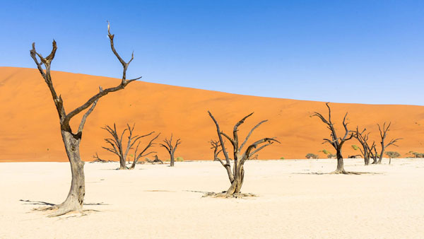
Deadvlei
Dead Camelthorn trees in Deadvlei
Deadvlei is another clay pan, about 2 km from Sossusvlei. A notable feature of Deadvlei is that it used to be an oasis with several camelthorn trees; afterward, the river that watered the oasis changed its course. The pan is thus punctuated by blackened, dead camelthorn trees, in vivid contrast to the shiny white of the salty floor of the pan and the intense orange of the dunes. This creates a particularly fascinating and surrealistic landscape, that appears in innumerable pictures and has been used as a setting for films and videos.
Hiddenvlei
Hiddenvlei (or Hidden Vlei) is another vlei in the Sossusvlei area. It is 4 km from the 2×4 parking, and it is the least visited.
Petrified dunes
Petrified dunes are dunes that have solidified to rock and are found in several places in the Sossusvlei area.
VIEW TOURS & SAFARIS
Namibia is a country in Southern Africa. Its western border is the Atlantic Ocean. It shares land borders with Zambia and Angola to the north, Botswana to the east, and South Africa to the south and east. Although it does not border Zimbabwe, less than 200 meters (660 feet) of the Botswanan right bank of the Zambezi River separates the two countries. Namibia gained independence from South Africa on 21 March 1990, following the Namibian War of Independence. It’s capital and largest city is Windhoek. Namibia is a member state of the United Nations (UN), the Southern African Development Community (SADC), the African Union (AU), and the Commonwealth of Nations.