
Rehoboth Tours & Safaris
Rehoboth Tours and Safaris is a Zimbabwe-registered company with offices in the tourist capital of Victoria Falls, Zimbabwe. The Company specializes in providing services such as Mid-budget to Luxury Safari lodges, Budget Camping, Hwange Safari trips, Chobe full-day trips, Hotel Reservations, packaged tours, Activities, and Airport transfers in Zimbabwe, Botswana, Zambia, South Africa, and Namibia.
ZIMBABWE
TOP
ATTRACTIONS
EVERYDAY IS A HOLIDAY
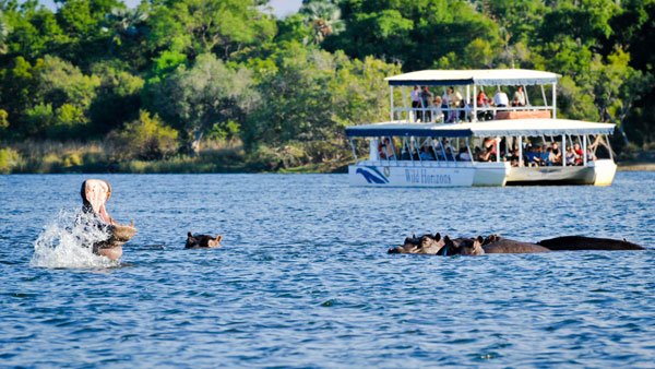
Zimbabwe is home to Victoria Falls – the world’s largest sheet of falling water. The falls span the entire breadth of the Zambezi River at more than 1,700m wide and drop approximately 108m.They were named in 1855 after the British Queen Victoria, by Scottish explorer David Livingstone. They are known locally by the Kalolo-Lozi people as Mosi-oa-Tunya, ‘the smoke that thunders.’ In 2019, the falls slowed to a trickle after the worst drought in a century in the region. And many other Zimbabwe attractions
Victoria Falls
Type Cataract waterfall
Total height 108 m (355 ft)
Number of drops 2
Watercourse Zambezi River
UNESCO World Heritage Site
Official name Mosi-oa-Tunya / Victoria Falls
Type Natural
Region List of World Heritage Sites in Africa
Victoria Falls (Lozi: Mosi-oa-Tunya, “The Smoke That Thunders”; Tonga: Shungu Namutitima, “Boiling Water”) is a waterfall on the Zambezi River in southern Africa, which provides habitat for several unique species of plants and animals. It is located on the border between Zambia and Zimbabwe and is one of the world’s largest waterfalls, with a width of 1,708 m (5,604 ft).
Archaeological sites and oral history describe a long record of African knowledge of the site. Though known to some European geographers before the 19th century, Scottish missionary David Livingstone identified the falls in 1855, providing the English colonial’s name of Victoria Falls after Queen Victoria. Since the mid-20th century, the site has been an increasingly important source of tourism. Zambia and Zimbabwe both have national parks and tourism infrastructure at the site. Research in the late 2010s found that climate change-caused precipitation variability is likely to change the character of the fall.
Name origins
David Livingstone gazing upon the falls, in bronze, from the Zambian shore
David Livingstone, the Scottish missionary and explorer, is the first European recorded to have viewed the falls on 16 November 1855, from what is now known as Livingstone Island, one of two land masses in the middle of the river, immediately upstream from the falls near the Zambian shore. Livingstone named his sighting in honour of Queen Victoria, but the Sotho language name, Mosi-oa-Tunya—”The Smoke That Thunders”—continues in common usage. The World Heritage List officially recognises both names. Livingstone also cited an older name, Seongo or Chongwe, which means “The Place of the Rainbow”, as a result of the constant spray.
19th century
In November 1855, David Livingstone was the first European who saw the falls, when he travelled from the upper Zambezi to the mouth of the river between 1852 and 1856. The falls were well known to local tribes, and Voortrekker hunters may have known of them, as may the Arabs under a name equivalent to “the end of the world”. Europeans were sceptical of their reports, perhaps thinking that the lack of mountains and valleys on the plateau made a large fall unlikely.
Livingstone had been told about the falls before he reached them from upriver and was paddled across to a small island that now bears the name Livingstone Island in Zambia. Livingstone had previously been impressed by the Ngonye Falls further upstream but found the new falls much more impressive and gave them their English name in honour of Queen Victoria. He wrote of the falls, “No one can imagine the beauty of the view from anything witnessed in England. It had never been seen before by European eyes, but scenes so lovely must have been gazed upon by angels in their flight.”
In 1860, Livingstone returned to the area and made a detailed study of the falls with John Kirk. Other early European visitors included Portuguese explorer Serpa Pinto, Czech explorer Emil Holub, who made the first detailed plan of the falls and its surroundings in 1875 (published in 1880), and British artist Thomas Baines, who executed some of the earliest paintings of the falls. Until the area was opened up by the building of the railway in 1905, though, the falls were seldom visited by other Europeans. Some writers believe that the Portuguese priest Gonçalo da Silveira was the first European to catch sight of the falls back in the sixteenth century.
Victoria Falls Bridge initiates tourism
European settlement of the Victoria Falls area started around 1900 in response to the desire of Cecil Rhodes’ British South Africa Company for mineral rights and imperial rule north of the Zambezi, and the exploitation of other natural resources such as timber forests north-east of the falls, and ivory and animal skins. Before 1905, the river was crossed above the falls at the Old Drift, by dugout canoe or a barge towed across with a steel cable. Rhodes’ vision of a Cape-Cairo railway drove plans for the first bridge across the Zambezi. He insisted it beisuilt where the spray from the falls would fall on passing trains, so the site at the Second Gorge was chosen. (See the main article Victoria Falls Bridge for details. From 1905 the railway offered accessible travel from as far as the Cape in the south and from 1909, as far as the Belgian Congo in the north. In 1904 the Victoria Falls Hotel was opened to accommodate visitors arriving on the new railway. The falls became an increasingly popular attraction during British colonial rule of Northern Rhodesia (Zambia) and Southern Rhodesia (Zimbabwe), with the town of Victoria Falls becoming the main tourist centre.
Activities in the area include Whitewater rafting in the gorges, bungee jumping from the bridge, game fishing, horse riding, kayaking, and flights over the falls etc
A famous feature is the naturally formed “Armchair” (now sometimes called “Devil’s Pool”), near the edge of the falls on the Zambian side, along the western tip of Livingstone Island. When the river flow is at a certain level, usually between September and December, a rock barrier forms an eddy with minimal current, allowing adventurous swimmers to splash around in relative safety in front of the point where the water cascades over the falls. One death of a tourist guide has been reported.
Hwange National Park
IUCN category II (national park)
Location Matabeleland North, Zimbabwe
Nearest city Hwange
Area 14,651 km2 (5,657 sq mi)
Established 1928 as a Game Reserve, (1961 as a National Park)
Governing body Zimbabwe Parks and Wildlife Management Authority
Hwange National Park (formerly Wankie Game Reserve) is the largest natural reserve in Zimbabwe. It is around 14,600 sq km in area. It lies in the northwest of the country, just off the main road between Bulawayo and Victoria Falls. The nearest town is Dete. Histories of the region’s pre-colonial days and its development as a game reserve and National Park are available online.
History of the park
Hwange National Park was founded in 1928. It is considered for inclusion in the five-nation Kavango – Zambezi Trans frFrontieronservation Area.
Poaching incidents
In 2011, nine elephants, five lions, and two buffaloes were killed by poachers.
In October 2013 it was discovered that poachers killed a large number of African elephants with cyanide after poisoning their waterhole. Conservationists have claimed the incident to be the largest illegal killing of animals in Southern Africa in 25 years. Two aerial surveys were carried out to determine the extent of the deaths, 19 carcasses were identified in the first survey and a further 84 carcasses in the second survey. Three of the poachers were caught, arrested, tried, convicted, and, sentenced. All royal game and elephant poaching offenses now have a mandatory 9-year sentence and the supply chain is also targeted.
Cecil and Xanda hunting incidents.
On or about 1 July 2015, Cecil, a lion who had lived in Hwange National Park for 13 years, was killed. This action spurred widespread social media coverage and a petition calling for Zimbabwe’s president Robert Mugabe to outlaw big game hunting permits. Walter Palmer, the admitted killer of Cecil, had a permit and was not charged with any crime, as all his papers were in order. Authorities in Zimbabwe have said he is free to visit the country. Charges were initially laid against Theo Bronkhorst, Palmer’s guide, for “failing to stop an illegal hunt” but these were later thrown out of court.
Two years after Cecil’s killing, his son Xanda met a similar fate. Unlike that of his father, Xanda’s killing was not termed illegal, though it did provoke outrage.
The game at a pan in a vlei or seasonal wetland
The park is close to the edge of the Kalahari Desert, a region with little water and very sparse, xerophile vegetation. The Kalahari woodland is dominated by Zambezi Teak, Sand Camwood (Baphia), and Kalahari bauhinia. Seasonal wetlands form grasslands in this area.
The north and northwest of the park are dominated by mopane woodland.
Although it has been argued that elephant populations cause changes in vegetation structure, some recent studies suggest that this is not the case, even with the large increases in the elephant population recorded in the late 1980s.
Geography and geology
Most of the park is underlain by Kalahari Sands. In the northwest there are basalt lava flows of the Batoka Formation, stretching from south of Bumbusi to the Botswana border. In the north-central area, from Sinamatella going eastwards, there are granites and gneisses of the Kamativi-Dete Inlier, and smaller inliers of these rocks are found within the basalts in the northwest.
The north and northwest of the park are drained by the Deka and Lukosi Rivers and their tributaries, and the far south of the park is drained by the Gwabadzabuya River, a tributary of the Nata River. There are no rivers in the rest of the park, although there are fossil drainage channels in the main camp and Linkwasha areas, which form seasonal wetlands. In these areas without rivers, grassy pan depressions and pans have formed. Some of these pans, such as many of the pans in the Shumba area, fill with rainwater, while others, such as Ngweshla, Shakwanki, and Nehimba, are fed by natural groundwater seeps. Many of the pans are additionally supplied by water pumped from underground by park authorities.
Archaeological, historical, and cultural sites
People have lived in the region for tens of thousands of years, as attested by numerous archaeological sites ranging from the early Stone Age to the historic era. Stone age foragers hunted and gathered in the region, leaving numerous sites with stone tools throughout today’s park. They made engravings of animal hoofprints on sandstone rock shelter walls with some small rock paintings in the park’s northwest. Iron-age people built large and small stone-walling sites in the park, such as Mtoa and the Bumbusi National Monument.
Matobo National Park
IUCN category II (national park)
Nearest city Bulawayo
Area 424 km2 (164 sq mi)
Established 1926
Governing body Zimbabwe Parks and Wildlife Management Authority
UNESCO World Heritage Site
Official name Matobo Hills
Type Cultural
Designated 2003 (27th session)
Region Africa
The Matobo National Park forms the core of the Matobo or Matopos Hills, an area of granite kopjes and wooded valleys commencing some 35 kikilometers22 mi) south of Bulawayo, southern Zimbabwe. The hills were formed over 2 billion years ago with granite being forced to the surface, this has eroded to produce smooth “whaleback dwalas” and broken kopjes, strewn with boulders and interspersed with thickets of vegetation. Matopo/Matob was named by the Lozwi, who are the ancestors of Kalanga. A different tradition states that the first King, Mzilikazi Khumalo when told by the residents that the great granite domes were called madombo he replied, possibly half jest, “We will call them matobo” – an IsiNdebele play on ‘Bald heads’.
The Hills cover an area of about 3100 km² (1200 sq mi), of which 424 km² (164 sq mi) is National Park, the remainder being largely communal land and a small proportion of commercial farmland. The park extends along the Thuli, Mtshelele, Maleme, and Mpopoma river valleys. Part of the national park is set aside as a 100 km² (39 sq mi) game park, which has been stocked with the game including the white rhinoceros. The highest point in the hills is the promontory named Gulati (1549 m; 5082 ft) just outside the northeastern corner of the park.
Administratively, Matobo National Park incorporates the Lake Matopos Recreational Park, being the area around Hazelside, Sandy Spruit, and Lake Matopos. The national park is located within the southern Africa bushveld ecoregion.
History
The national park is the oldest in Zimbabwe, established in 1926 as Rhodes Matopos National Park, a bequest from Cecil Rhodes. The original park borders extended well to the south and east of the current park. These areas were redesignated for settlement as part of a compromise between the colonial authorities and the local people, creating the Khumalo and Matobo Communal Lands. The park area then increased with the acquisition of World’s View and Hazelside farms to the north.
The current name Matobo reflects the correct vernacular pronunciation of the area.
The Matobo Hills were designated as a UNESCO World Heritage Site in 2003. The area “exhibits a profusion of distinctive rock landforms rising above the granite shield that covers much of Zimbabwe”.
Features
Flora
The Matobo Hills is an area of high botanic diversity, with over 200 species of tree recorded in the national park, including the mountain acacia, wild pear, and the paperbark acacia. There are also many aloes, wild herbs and over 100 grass species. Many types of rare endemic plants have been recorded.
Fauna
White rhino and calf in the game park, Matobo National Park
Matobo National Park has a wide diversity of fauna: 175 bird, 88 mammal, 39 snake and 16 fish species. Game includes white rhinos, sable antelopes, impala and leopards. The park contains the world’s densest population of the latter, due to the abundance of hyrax, which make up 50% of their diet. The game park in the west has been restocked with white and black rhinos, the former from KwaZulu-Natal in the 1960s and the latter from the Zambezi Valley in the 1990s. It has been designated as an Intensive Protection Zone for the two species, as well as hyenas, hippopotami, giraffes, zebras, wildebeests and ostriches.
Matobo National Park contains the highest concentration of black eagles, and breeding pairs of these birds, worldwide.
Mother and Child Kopje in the game park, Matobo National Park
A limnological research centre has operated since 1950 at Maleme Dam and researched species such as the yellow-fish, Barbus mattozi.
Geography and geology
The Matobo Hills are composed entirely of granite, making up the Matopos Batholith. The granite weathers into fantastic shapes, such as the balancing rocks known as Mother and Child Kopje. Between the granite mountains, narrow valleys form. These are often swampy valleys known as dambos or vleis, due to runoff from the whaleback mountains.These valleys form the headwaters of the Maleme, Mpopoma and Mtsheleli rivers, and the source of the Thuli River is just east of the park.
Archaeological, historical and cultural sites
Mt Effefe ca. 1900.
San (Bushmen) lived in the hills about 2,000 years ago, leaving a rich heritage in hundreds of rock paintings. There are over 3,000 registered rock art sites, with the main periods of painting being between 320 and 500 C.E. In the many crevices and caves, clay ovens and other historic artefacts have been found, and various archaeological finds date back as far as the Pre-Middle Stone Age, around 300,000 B.P. The following major sites have been developed for tourist access:
Bambata Cave is a major archaeological site, located in the west of the national park, north of the game park on the Kezi-Bulawayo Road. The frieze includes elephants, giraffes, warthogs, tsessebe and mongoose.
Inanke Cave has the most extensive paintings, located in a remote cave accessible by a three-hour hike from Toghwana Dam. Along the route of the hike is an Iron Age furnace.
Nswatugi Cave.
Nswatugi Cave contains beautiful friezes of giraffes, elephants and kudu. Access is from Circular Drive, west of Maleme Dam. A human skeleton was found here dating 42000 BC belonged to Middle Stone Age.
Pomongwe Cave, near Maleme Dam, was damaged by a preservation attempt in 1965, where linseed oil was applied to the paintings. Archaeological digs within and downslope of the cave revealed 39,032 stone tools, several hearths, with the main fire-making areas were in the centre of the cave floor. Bone fragments showed that hyrax formed a major part of the meat component of the diet of early human inhabitants of the cave, which also included tortoise, baboons and larger game animals. The oldest material on the site is probably pre-Middle Stone Age.
White Rhino Shelter is a small site near Gordon Park, on the main tarred road through the park. The frieze includes the outline of large rhinos, which is said to have inspired the re-introduction of the species in the 1960s.
The grandeur and stillness of the hills has contributed to their hallowed reputation, especially to the Shona and Ndebele people. Many rituals and other religious activities are performed in the hills. Before the colonial era, it was the headquarters of the spiritualist oracle, the Mlimo.
Cecil Rhodes tomb on Malindidzimu
The hills were the scene of the famous indaba between white settlers and Ndebele leaders in 1896—the Second Matabele War, known in Zimbabwe as the First Chimurenga—which ended with the assassination of the Mlimo by Frederick Russell Burnham, the American scout, in one of the Matobo caves. Upon learning of the death of the Mlimo, Cecil Rhodes boldly walked alone and unarmed into this Ndebele stronghold and persuaded the impi to lay down their arms. During the indaba it was also in these hills that Robert Baden-Powell, the Founder of Scouting, first learned woodcraft, the fundamentals of scouting, from Burnham. Today much of the pottery and artifacts found on cave floors and most of the clay grain bins in the hills are remnants from the 1896 rebellion era. There are other reminders too – bronze plaques dotting the area mark the sites of armed forts or brief skirmishes.
Shangani Patrol memorial at World’s View
Cecil Rhodes, Leander Starr Jameson, and several other leading early white settlers, including Allan Wilson and all the members of the Shangani Patrol killed in the First Matabele War, are buried on the summit of Malindidzimu, the ‘hill of the spirits’ — this is a great source of controversy in modern Zimbabwe as this is considered a sacred place by nationalists and indigenous groups. This mount is also referred to as the World’s View. (Not to be confused with the World’s View, Nyanga). Mzilikazi is also buried at Matopos Hill.
A memorial shrine, erected by the Memorable Order of Tin Hats (MOTH), an organization that seeks to commemorate the sacrifice of Rhodesian servicemen and women during World War One and World War Two, can be accessed in the park.
Accommodation and camping
Black Eagle and Fish Eagle Lodges at Maleme Rest Camp.
Maleme Camp
This is the main camp in the centre of the park, and hosts the park headquarters. All accommodation is self-catering. There are eighteen lodges and six chalets, the former fully equipped and the latter with communal ablutions and without crockery or cutlery. Three of the lodges, Imbila, Black Eagle and Fish Eagle, have fantastic views over the Maleme Gorge. Imbila Lodge offers a higher standard of luxury with ensuite bathrooms and teak furniture. Camping and caravan sites are situated along the eastern shores of Maleme Dam.
Gordon Park Scout Camp.
Privately operated camps and sites
The Boy Scouts Association of Zimbabwe operates a camp called Gordon Park, in the north of the Mtsheleli Valley. Gordon Park is a 115-ha lease from the Parks and Wildlife Management Authority and is maintained as far as possible close to natural conditions. In addition to camping sites for Scout Troops there is a small cottage. The Girl Guides Association of Zimbabwe maintains a camp site at Rowallan Park, in the north of the Mtsheleli Valley.
Big Cave Camp is a privately owned camp, bordering the Matobo National Park. The Camp offers four-star accommodation in seven granites under thatch lodges and separate camping facilities elsewhere on the property. Activities on offer include game drives, game walks, bird watching, tours to famous rock art galleries, as well as tours to Rhodes Grave. The Big Cave property is approximately 2,000 acres (8.1 km2), and is ideal for walking and birdwatching. Facilities include a natural rock pool for swimming, the “Leopards Lair” bar and dining area which incorporates a huge granite boulder into the building, as well as separate library area.
Camp Amalinda and Matobo Ingwe Lodge are commercial lodges.
Tourism
Dams such as Maleme and their environs offer opportunities for game viewing, hiking, fishing and boating.
Access
By road from Bulawayo: Take Robert Mugabe Way in the city centre; this turns into Matopos Road which continues south some 30 km to the park boundary. This is a two-lane tarred road. A single lane tarred road continues to Maleme Dam and Rest Camp. The remaining roads in the park are gravel or earth, but suitable for most vehicles. However, access to Toghwana Dam during the rainy season may require a four-wheel drive.
The park can also be reached from Gwanda: by taking the Thuli-Makwe road towards Kezi and turning north on the main Kezi-Bulawayo Road.
Game viewing
Some game can be seen throughout the park, with regular sightings of white rhino, sable antelope and impala. However, the best viewing is to be had in the 105 km2 Game Park, in the west of the national park. The game park, also known as Whovi or Hove Wild Area was established with animals translocated from the border areas of Hwange National Park. It has been restocked with white and black rhinos. Other animals to be seen include sable antelope, giraffe, zebra, impala, wildebeest and ostrich. On rare occasion in the late afternoon to early evening visitors, can be lucky enough to spot leopard, with many nights being disturbed by the ruckus of baboons screaming due to leopard attacks. There are two game viewing hides.
Hiking
With its scenery, climate and safe environment, Matobo has a number of hiking trails. Shorter hikes and walks include:
Lakeside walk, Maleme Dam, from Fish Eagle lodge
Mount Pomongwe, near Maleme Camp
Maleme Camp to Pomongwe Cave rock paintings
Longer hikes include:
Climbing mount Shumbashawa, near Gordon Park
Climbing Nyahwe mountain
Hike from Toghwana Dam to Inanke Cave and rock paintings.
Accompanied hikes, with an armed game scout are available from Maleme Rest Camp
Horse riding near Maleme Dam.
Trail riding
Supervised horse trails are arranged by the Parks and Wildlife staff. There are two routes:
From Maleme Camp and visiting scenic locations in the Maleme valley and environs.
From Whitewater Office into the game park for game viewing.
Fishing
The many dams in the park allow for pleasant fishing, notably for Tilapia and bass. Bass was stocked into seven of the park’s dams from the research station at Maleme Dam. The park entry fee includes a fishing license.
Boating
Boating is possible on the larger dams, such as Maleme, Mtshelele, Toghwana and Lake Matopos. Privately owned boats are permitted subject to the approval of the parks’ officials.
In popular culture
A Zimbabwean cheese has been named Matopos, after the hills.
The name of the park has been used twice in films: According to director Stéphanie Machuret, the title and landscape in her 2007 film Matopos, about a traditional healer, was inspired by the park. The name was also used for the fictional Democratic Republic of Matobo in the film The Interpreter.
Great Zimbabwe
Location Masvingo Province, Zimbabwe
Type Settlement
Part of the Kingdom of Zimbabwe
Area 7.22 square kilometers (1,780 acres)
History
Material Granite
Founded 9th century AD
Abandoned 15th century AD
Periods Late Iron Age
Cultures Kingdom of Zimbabwe
Site notes
UNESCO World Heritage Site
Official name Great Zimbabwe National Monument
Great Zimbabwe is a medieval city in the south-eastern hills of Zimbabwe near Lake Mutirikwi and the town of Masvingo. It is thought to have been the capital of a great kingdom during the country’s Late Iron Age about which little is known. Construction on the city began in the 9th century and continued until it was abandoned in the 15th century. The edifices are believed to have been erected by the ancestral Shona. The stone city spans an area of 7.22 square kilometers (2.79 square miles) and could have housed up to 18,000 people at its peak, giving it a population density of approximately 2,500 per square kilometer. It is recognized as a World Heritage Site by UNESCO.
Great Zimbabwe is believed to have served as a royal palace for the local monarch. As such, it would have been used as the seat of political power. Among the edifice’s most prominent features were its walls, some of which are eleven meters high. They were constructed without mortar (dry stone). Eventually, the city was abandoned and fell into ruin.
The earliest document mentioning the Great Zimbabwe ruins was in 1531 by Vicente Pegado, captain of the Portuguese garrison of Sofala on the coast of modern-day Mozambique, who recorded it as Symbaoe. The first confirmed visits by Europeans were in the late 19th century, with investigations of the site starting in 1871. Some later studies of the monument were controversial, as the white government of Rhodesia pressured archaeologists to deny its construction by black Africans. Great Zimbabwe has since been adopted as a national monument by the Zimbabwean government, and the modern independent state was named after it.
The word great distinguishes the site from the many smaller ruins, now known as “zimbabwes”, spread across the Zimbabwe Highveld. There are 200 such sites in southern Africa, such as Bumbusi in Zimbabwe and Manyikeni in Mozambique, with monumental, mortarless walls.
Name of Zimbabwe
The conical tower inside the Great Enclosure at Great Zimbabwe
Zimbabwe is the Shona name of the ruins, first recorded in 1531 by Vicente Pegado, captain of the Portuguese garrison of Sofala. Pegado noted that “The natives of the country call these edifices Symbaoe, which according to their language signifies ‘court'”.
The name contains dzimba, the Shona term for “houses”. There are two theories for the etymology of the name. The first proposes that the word is derived from Dzimba-dza-mabwe, translated from Shona as “large houses of stone” (dzimba = plural of imba, “house”; mabwe = plural of bwe, “stone”). A second suggests that Zimbabwe is a contracted form of dzimba-hwe, which means “venerated houses” in the Zezuru dialect of Shona, as usually applied to the houses or graves of chiefs.
Settlement
The majority of scholars believe that it was built by members of the Gokomere culture, who were the ancestors of the modern Shona in Zimbabwe.
The Great Zimbabwe area was settled by the 4th century AD. Between the 4th and the 7th centuries, communities of the Gokomere or Ziwa cultures farmed the valley, and mined and worked iron, but built no stone structures. These are the earliest Iron Age settlements in the area identified from archaeological diggings.
Construction and growth
Construction of the stone buildings started in the 11th century and continued for over 300 years. The ruins at Great Zimbabwe are some of the oldest and largest structures located in Southern Africa and are the second oldest after nearby Mapungubwe in South Africa. Its most formidable edifice, commonly referred to as the Great Enclosure, has walls as high as 11 m (36 ft) extending approximately 250 m (820 ft). David Beach believes that the city and its proposed state, the Kingdom of Zimbabwe, flourished from 1200 to 1500, although a somewhat earlier date for its demise is implied by a description transmitted in the early 1500s to João de Barros. Its growth has been linked to the decline of Mapungubwe from around 1300, due to climatic change or the greater availability of gold in the hinterland of Great Zimbabwe.
Traditional estimates are that Great Zimbabwe had as many as 18,000 inhabitants at its peak. However, a more recent survey concluded that the population likely never exceeded 10,000. The ruins that survive are built entirely of stone; they span 730 ha (1,800 acres).
Detail of the wall with lichen, 1975.
In 1531, Vicente Pegado, Captain of the Portuguese Garrison of Sofala, described Zimbabwe thus:
Among the gold mines of the inland plains between the Limpopo and Zambezi rivers, there is a fortress built of stones of marvellous size, and there appears to be no mortar joining them … This edifice is almost surrounded by hills, upon which are others resembling it in the fashioning of stone and the absence of mortar, and one of them is a tower more than 12 fathoms [22 m] high. The natives of the country call these edifices Symbaoe, which according to their language signifies court.
— Vicente Pegado
The ruins form three distinct architectural groups. They are known as the Hill Complex, the Valley Complex, and the Great Enclosure. The Hill Complex is the oldest and was occupied from the 9th to 13th centuries. The Great Enclosure was occupied from the 13th to 15th centuries and the Valley Complex from the 14th to 16th centuries. Notable features of the Hill Complex include the Eastern Enclosure, in which it is thought the Zimbabwe Birds stood, a high balcony enclosure overlooking the Eastern Enclosure, and a huge boulder in a shape similar to that of the Zimbabwe Bird. The Great Enclosure is composed of an inner wall, encircling a series of structures and a younger outer wall. The Conical Tower, 5.5 m (18 ft) in diameter and 9 m (30 ft) high, was constructed between the two walls. The Valley Complex is divided into the Upper and Lower Valley Ruins, with different periods of occupation.
There are different archaeological interpretations of these groupings. It has been suggested that the complexes represent the work of successive kings: some of the new rulers founded a new residence. The focus of power moved from the Hill Complex in the 12th century, to the Great Enclosure, the Upper Valley, and finally the Lower Valley in the early 16th century. The alternative “structuralist” interpretation holds that the different complexes had different functions: the Hill Complex was a temple, the Valley complex was for the citizens, and the Great Enclosure was used by the king. More elaborate structures were probably built for the kings, although it has been argued that the dating of finds in the complexes does not support this interpretation.
Notable artifacts
Copy of Zimbabwe Bird soapstone sculpture
The most important artifacts recovered from the Monument are the eight Zimbabwe Birds. These were carved from micaceous schist (soapstone) on the tops of monoliths the height of a person. Slots in a platform in the Eastern Enclosure of the Hill Complex appear designed to hold the monoliths with the Zimbabwe birds, but as they were not found in situ it cannot be determined which monolith and bird were. Other artifacts include soapstone figurines (one of which is in the British Museum, pottery, iron gongs, elaborately worked ivory, iron and copper wire, iron hoes, bronze spearheads, copper ingots and crucibles, gold beads, bracelets, pendants, and sheaths. Glass beads and porcelain from China and Persia among other foreign artifacts were also found, attesting to the international trade linkages of the Kingdom. In the extensive stone ruins of the great city, remain today, including eight, monolithic birds carved in soapstone. It is thought that they represent the bateleur eagle – a good omen, protective spirit, and messenger of the gods in Shona culture.
Trade
Archaeological evidence suggests that Great Zimbabwe became a center for trading, with artifacts suggesting that the city formed part of a trade network linked to Kilwa and extending as far as China. Copper coins found at Kilwa Kisiwani appear to be of the same pure ore found on the Swahili coast. This international trade was mainly in gold and ivory; some estimates indicate that more than 20 million ounces of gold were extracted from the ground. That international commerce was in addition to the local agricultural trade, in which cattle were especially important. The large cattle herd that supplied the city moved seasonally and was managed by the court. Chinese pottery shards, coins from Arabia, glass beads, and other non-local items have been excavated in Zimbabwe. Despite these strong international trade links, there is no evidence to suggest an exchange of architectural concepts between Great Zimbabwe and centers such as Kilwa.
Decline
The causes for the decline and ultimate abandonment of the site around 1450 have been suggested as due to be a decline in trade compared to sites further north, the exhaustion of the gold mines, political instability, famine, and water shortages induced by climatic change. The Mutapa state arose in the 15th century from the northward expansion of the Great Zimbabwe tradition, having been founded by Nyatsimba Mutota from Great Zimbabwe after he was sent to find new sources of salt in the north; (this supports the belief that Great Zimbabwe’s decline was due to a shortage of resources). Great Zimbabwe also predates the Khami and Nyanga cultures.
Damage to the ruins
Damage to the ruins has taken place throughout the last century. The removal of gold and artifacts in amateurist diggings by early colonial antiquarians caused widespread damage, notably diggings by Richard Nicklin Hall. More extensive damage was caused by the mining of some of the ruins for gold. Reconstruction attempts since 1980 caused further damage, leading to the alienation of the local communities from the site. Another source of damage to the ruins has been due to the site being open to visitors with many cases of people climbing the walls, walking over archaeological deposits, and the over-use of certain paths all have had major impacts on the structures at the site. These are in conjunction with damages due to the natural weathering that occurs over time due to vegetation growth, the foundations settling, and erosion from the weather.
Kariba, Zimbabwe
Coordinates: 16°31′S 28°48′ECoordinates: 16°31′S 28°48′E
Country Zimbabwe
Province Mashonaland West
District Kariba District
Population (2022 census)
- Total 27,600
Time zone UTC+2 (CAT)
Area code 061
Kariba is a resort town in Mashonaland West province, Zimbabwe, located close to the Kariba Dam at the northeastern end of Lake Kariba, near the Zambian border. According to the 2022 Population Census, the town had a population of 27,600.
Located in the Zambezi Valley, Kariba is well known for its balmy climate and proximity to Lake Kariba, which draws in thousands of tourists all year round.
History
The pre-colonial population of the area was Tonga.
The town was established to house workers who were constructing the dam in the mid to late 1950s and was constructed by the contractor Costain. After the completion of the dam wall and the power station (Kariba South Power Station), quite a few impressive monuments were built in the early 1960s i.e., the Roman Catholic church located at the Kariba Heights (St Barbara) and next to it the Pat McClean Theatre named after Patricia McClean a well-known wealthy resident of Kariba Heights.
Geography
Kariba is located on Lake Kariba, a reservoir created by Kariba Dam on the Zambezi River.[4] Kariba has three main suburbs: Mahombekombe, the older poorer lakeshore high-density suburb, Nyamhunga the newer high-density suburb and Kariba Heights, the wealthier hilltop suburb and location of the Operation Noah monument. As the name suggests the heights overlook the surrounding region and offer impressive views of Lake Kariba and the opposite lakeshore to the south.
The town has road links connecting it to Harare and the border of Zambia. It is serviced by Kariba Airport and has a ferry service to Victoria Falls via Mlibizi Fishing Camp.
Economy
Kariba town is the center of the tourist industry for the Lake Kariba region. Kariba town provides accommodation in various hotels and lodges. There are two casinos in the town. Many of the attractions in Kariba for tourists are water-based. Fishing, game-viewing, and house boating are the most popular activities. Tourists also visit the Kariba Dam wall and local crocodile farms.
The Zimbabwe Electricity Supply Authority ZESA employs workers in the hydroelectric power station. Kapenta fishing is also an important industry, though it was affected by the nationwide fuel shortages and the 2010s drought.
Challenges
In the twenty-first century, the town of Kariba faced many of the nationwide problems brought on by the depressed national economy, including a lack of foreign currency. The town had difficulty in revenue collection. As a result, its fleet did not receive proper maintenance or replacements, which was also true of its water and sewage system, which suffered chronic pump breakdowns. Kariba also continued to have a large number of unoccupied housing units, left over from the construction boom, units that generated no income.
The restructuring of industry in the early nineties, followed by Zimbabwe’s economic crisis in the 2000s, greatly impacted Kariba’s tourist potential. Many former visitors and residents were involved in trade and agriculture and the impact of the country’s crisis led to a decline in domestic tourism as much of the middle class, who were the mainstay of Kariba’s tourism industry began to emigrate. In addition, a lack of investment in the city’s airport and infrastructure has seen the city fall behind nearby destinations such as Livingstone and Victoria Falls, which offer easy access to Johannesburg, Dubai, and London. Once ubiquitous, South African tourists increasingly prefer cheaper and more accessible destinations like Mauritius, Tofo Beach, and Pemba. As a result, its population has stagnated to fewer than 30,000 inhabitants today.
Another challenge to the town, is the increasingly outdated infrastructure, particularly Kariba Dam. Years of under-investment threaten the longevity of the dam and its ability to generate power, posing a challenge to the economies of Zambia and Zimbabwe.
Kariba has a tropical savanna climate (Köppen climate classification Aw), with warm winters and very hot summers, and a marked drier season in the winter. Although it is relatively cooler than typical tropical places in the winter and does get occasional 5 °C (41 °F) lows, Kariba nevertheless meets the minimum requirements to be in the savanna climate zone, making it one of few locations in Zimbabwe within this classification. The city’s low elevation by Zimbabwean standards, lakeside location, northern locality, and proximity to the Intertropical Convergence Zone shape its climate. Average winter high temperatures, from May to August, range from 24.7 to 26.8 °C (76.4 to 80.3 °F). July is the coolest month with an average daily temperature of 20.1 °C (68.2 °F). Low temperatures fall below 10 °C (50 °F) about 10–15 nights during the winter season, after the passage of cold fronts from the southeast that may sometimes produce winter precipitation.
Type of dam Arch dam
Impounds Zambezi River
Height 128 m (420 ft)
Length 579 m (1,900 ft)
Width (crest) 13 meters (43 ft)
Width (base) 24 meters (79 ft)
Reservoir
Creates Lake Kariba
Total capacity 180 km3 (150,000,000 acre⋅ft)
Catchment area 663,000 km2 (256,000 sq mi)
Surface area 5,400 km2 (2,100 sq mi)
Maximum length 280 km (170 mi)
Maximum water depth 97 m (318 ft)
Power Station
Turbines North: 4 x 150 MW (200,000 hp), 2 x 180 MW (240,000 hp) Francis-type
South: 6 x 125 MW (168,000 hp), 2 x 150 MW (200,000 hp) Francis-type
Installed capacity North: 960 MW
South: 1050 MW
Total: 1,626 MW (2,181,000 hp)
Annual generation 6,400 GWh (23,000 TJ)
The Kariba Dam is a double-curvature concrete arch dam in the Kariba Gorge of the Zambezi River basin between Zambia and Zimbabwe. The dam stands 128 meters (420 ft) tall and 579 meters (1,900 ft) long. [1] The dam forms Lake Kariba, which extends for 280 kilometers (170 mi) and holds 185 cubic kilometers (150,000,000 acre⋅ft) of water.
Construction
The dam was constructed on the orders of the Government of the Federation of Rhodesia and Nyasaland, a ‘federal colony’ within the British Empire. The double curvature concrete arch dam was designed by Coyne et Bellier and constructed between 1955 and 1959 by Impresit of Italy for $135,000,000 for the first stage with only the Kariba South power cavern. Final construction and the addition of the Kariba North Power cavern by Mitchell Construction was not completed until 1977 due to largely political problems for a total cost of $480,000,000. During construction, 86 men lost their lives.
The dam was officially opened by Queen Elizabeth the Queen Mother on 17 May 1960.
Power generation
The Kariba Dam supplies 1,626 megawatts (2,181,000 hp) of electricity to parts of both Zambia (the Copperbelt) and Zimbabwe and generates 6,400 gigawatt-hours (23,000 TJ) per annum. Each country has its power station on the north and south bank of the dam respectively. The south station belonging to Zimbabwe has been in operation since 1960 and had six generators of 111 megawatts (149,000 hp) capacity each for a total of 666 megawatts (893,000 hp).
On November 11, 2013, it was announced to Zimbabwe’s Finance Minister, Patrick Chinamasa that the capacity at the Zimbabwean (South) Kariba hydropower station would be increased by 300 megawatts. The cost of upgrading the facility has been supported by a $319m loan from China. The deal is a clear example of Zimbabwe’s “Look East” policy, which was adopted after falling out with Western powers. Construction on the Kariba South expansion began in mid-2014 and was initially expected to be complete in 2019.
In March 2018, President Emmerson Mnangagwa commissioned the completed expansion of Kariba South Hydroelectric Power Station. The addition of two new 150 megawatts (200,000 hp) turbines, brings capacity at this station to 1,050 megawatts (1,410,000 hp). The expansion work was done by Sinohydro, for US$533 million. Work started in 2014 and was completed in March 2018.
The north station belonging to Zambia has been in operation since 1976, and has four generators of 150 megawatts (200,000 hp) each for a total of 600 megawatts (800,000 hp); work to expand this capacity by an additional 360 megawatts (480,000 hp) to 960 megawatts (1,290,000 hp) was completed in December 2013. Two additional 180 MW generators were added.
Zambezi river basin
The Kariba Dam project was planned and carried out by the Government of the Federation of Rhodesia and Nyasaland. The Federation was often referred to as the Central African Federation (CAF). The CAF was a ‘federal colony’ within the British Empire in southern Africa that existed from 1953 to the end of 1963, comprising the former self-governing British colony of Southern Rhodesia and the former British protectorates of Northern Rhodesia and Nyasaland. Northern Rhodesia had decided earlier in 1953 (before the Federation was founded) to build a dam within its territory, on the Kafue River, a major tributary of the Zambezi. It would have been closer to Northern Rhodesia’s Copperbelt, which needed more power. This would have been a cheaper and less grandiose project, with a smaller environmental impact. Southern Rhodesia, the richest of the three, objected to a Kafue dam and insisted that the dam be sited instead at Kariba. Also, the capacity of the Kafue dam was much lower than that at Kariba. Initially, the dam was managed and maintained by the Central African Power Corporation. The Kariba Dam is now owned and operated by the Zambezi River Authority, which is jointly and equally owned by Zimbabwe and Zambia.
Since Zambia’s independence, three dams have been built on the Kafue River: the Kafue Gorge Upper Dam, Kafue Gorge Lower Dam, and the Itezhi-Tezhi Dam.
Environmental impacts
Population displacement and resettlement
The dam under construction in the 1950s shows the dangers faced by the workers.
The creation of the reservoir forced the resettlement of about 57,000 Tonga people living along the Zambezi on both sides.
There are many different perspectives on how much resettlement aid was given to displaced Tonga. British author David Howarth described the efforts in Northern Rhodesia:
“Everything that a government can do on a meager budget is being done. Demonstration gardens have been planted, to try to teach Tonga more sensible methods of agriculture, and to try to find cash crops that they can grow. The hilly land has been plowed in ridge contours to guard against erosion. In Sinazongwe, an irrigated garden has grown a prodigious crop of pawpaws, bananas, oranges, lemons, and vegetables, and shown that the remains of the valley could be made prolific if only money could be found for irrigation. Cooperative markets have been organized, and Tonga is being taught to run them. Enterprising Tonga has been given loans to set itself up as a farmer. More schools have been built than Tonga ever had before, and most of Tonga is now within reach of dispensaries and hospitals.”
Anthropologist Thayer Scudder, who has studied these communities since the late 1950s, wrote:
“Today, most are still ‘development refugees’. Many live in less-productive, problem-prone areas, some of which have been so seriously degraded within the last generation that they resemble lands on the edge of the Sahara Desert.”
American writer Jacques Leslie, in Deep Water (2005), focused on the plight of the people displaced by the Kariba Dam and found the situation little changed since the 1970s. In his view, Kariba remains the worst dam resettlement disaster in African history.
River ecology
The Kariba Dam controls 90% of the total runoff of the Zambezi River, thus changing the downstream ecology dramatically.
Wildlife Rescue
From 1958 to 1961, Operation Noah captured and removed around 6,000 large animals and numerous small ones threatened by the lake’s rising waters.
Recent Activity
On 6 February 2008, the BBC reported that heavy rain could lead to a release of water from the dam, which would force 50,000 people downstream to evacuate. Rising levels led to the opening of the floodgates in March 2010, requiring the evacuation of 130,000 people who lived in the floodplain, and causing concerns that flooding would spread to nearby areas.
In March 2014, at a conference organized by the Zambezi River Authority, engineers warned that the foundations of the dam had weakened and there was a possibility of dam failure unless repairs were made.
On 3 October 2014, the BBC reported that “The Kariba Dam is in a dangerous state. Opened in 1959, it was built on a seemingly solid bed of basalt. But, in the past 50 years, the torrents from the spillway have eroded that bedrock, carving a vast crater that has undercut the dam’s foundations. … engineers are now warning that without urgent repairs, the whole dam will collapse. If that happened, a tsunami-like wall of water would rip through the Zambezi Valley, reaching the Mozambique border within eight hours. The torrent would overwhelm Mozambique’s Cahora Bassa Dam and knock out 40% of southern Africa’s hydroelectric capacity. Along with the devastation of wildlife in the valley, the Zambezi River Authority estimates that the lives of 3.5 million people are at risk.”
In June 2015 the Institute of Risk Management South Africa completed a Risk Research Report entitled Impact of the Failure of the Kariba Dam. It concluded: “Whilst we can debate whether the Kariba Dam will fail, why it might occur and when there is no doubt that the impact across the region would be devastating.”
In January 2016 it was reported that water levels at the dam had dropped to 12% of capacity. Levels fell by 5.58 meters (18.3 ft), which is just 1.75 meters (5 ft 9 in) above the minimum operating level for hydropower. Low rainfalls and overuse of the water by the power plants have left the reservoir near empty, raising the prospect that both Zimbabwe and Zambia will face water shortages.
In July and September 2018, The Lusaka Times reported that work had started relating to the plunge pool and cracks in the dam wall.
On 22 February 2019, Bloomberg reported “Zambia has reduced hydropower production at the Kariba Dam because of rapidly declining water levels” but “Zambia doesn’t anticipate power cuts as a result of shortages”. On 5 August that year, the same publication reported that the reservoir was near empty and that it may have to stop hydropower production.
As of November 2020, the water level in the Kariba reservoir has remained steady at around 25% capacity, up from nearly half that in November 2019. The Zambezi River Authority has stated that it is optimistic about rainfall estimates for the 2020/2021 rainfall season, allocating an increased amount of water for power production. As it sits now, the reservoir is holding 15.77 billion cubic meters of water, with the water line sitting at around 478.30 meters (1,569.23 ft), just above the minimum capacity for power generation of 475.50 meters (1,560.04 ft).
It was reported in February 2022 that rehabilitation work has been underway since 2017 on the Kariba Dam. The Zambezi River Authority (ZRA) said that work on the Kariba Dam Rehabilitation Project (KDRP), which includes efforts to reconfigure the plunge pool and rebuild the spillway gates, is scheduled to be finished in 2025. The rehabilitation of the dam is being financed by the European Union (EU), the World Bank, the Swedish government, and the African Development Bank (AfDB), with the Zambian and Zimbabwe governments contributing counterpart funding. The project’s goal is to guarantee the structural integrity of the Kariba Dam, assuring the sustained generation of power primarily for the benefit of the inhabitants of Zimbabwe and Zambia and the broader Southern African Development Community area. The work on redesigning the plunge pool involves bulk excavating the rock in the current pool to assist plunge pool stabilization and avoid additional scouring or erosion along the weak fault zone towards the dam foundation. This reshaping work will be accomplished by constructing a temporary water-tight cofferdam to complete the reshaping work under dry conditions.
Mana Pools National Park
Location Zimbabwe
Part of Mana Pools National Park, Sapi, and Chewore Safari Areas
Inscription 1984 (8th Session)
Area 6,766 square kilometers (2,612 sq mi)
Ramsar Wetland
Designated 3 May 2013
Mana Pools National Park is located in Zimbabwe Mana Pools National Park
Location of Mana Pools National Park in Zimbabwe
Mana Pools National Park is a 219,600-ha wildlife conservation area and national park in northern Zimbabwe. It is a region of the lower Zambezi River in Zimbabwe where the flood plain turns into a broad expanse of lakes after each rainy season. As the lakes gradually dry up and recede, the region attracts many large animals in search of water, making it one of Africa’s most renowned game-viewing regions.
The park was inscribed, in conjunction with the Sapi Safari Area (118,000 ha) and Chewore Safari Area (339,000 ha) as a single UNESCO World Heritage Site (for a total of 676,600 ha) in 1984. The Mana Pools were designated a Ramsar wetland of international importance on 3 January 2013. Mana Pools National Park is a World Heritage Site based on its pure wilderness and beauty. It is home to a wide range of mammals, over 350 bird species, and aquatic wildlife, and is one of the world’s wildest and best preserved natural ecological areas.
Ecology
Mana means ‘four’ in Shona, in reference to the four large permanent pools formed by the meanderings of the middle Zambezi. These 2,500 square kilometers of river frontage, islands, sandbanks, and pools, flanked by forests of mahogany, wild figs, ebonies, and baobabs, is one of the least developed national parks in Southern Africa. It has the country’s biggest concentration of hippopotami and crocodiles and large dry season mammal populations of the zebra, elephant, and Cape buffalo. The area is also home to other threatened species including the lion, cheetah, Cape wild dog, and near-threatened species including the leopard and the brown hyena.
When the area was inscribed by UNESCO, it was one of the most important refuges for eastern black rhinoceros populations in Africa, with about 500 animals. By 1994, poaching had reduced these to just 10 remaining rhinos, which were removed to another area for their protection.
Conservation
The area was saved from a hydroelectric scheme in the early eighties which would have seen the flooding of the area. The area’s ecology is affected by the regulation of the Kariba Dam and there are concerns that another potential dam on the Zambezi River, in the Mapata Gorge, might dramatically undermine the value of the area. Recently, the area was again saved from the Mupata Gorge hydroelectric scheme, where the chosen project was the Batoka Dam instead.
Surrounding area
The park is contiguous with Zambia’s Lower Zambezi National Park on the opposite side of the Zambezi River, and the larger UNESCO area is contiguous with the Urungwe Safari Area (287,000 ha), the Dande Safari Area (52,300 ha) and the Doma Safari Area (76,400 ha).
Khami
Location Matabeleland North Province, Zimbabwe
Type Settlement
History
Periods Late Iron Age
UNESCO World Heritage Site
Official name Khami Ruins National Monument
Inscription 1986 (10th Session)
Khami (also written as Khame, Kame, or Kami) is a ruined city located 22 kilometers west of Bulawayo, in Zimbabwe. It was once the capital of the Kingdom of Butwa of the Torwa dynasty. It is now a national monument and became a UNESCO World Heritage Site in 1986.
History
Khami was the capital of the Torwa dynasty for about 200 years from around 1450 and appears to have been founded at the time of the disappearance of the state at Great Zimbabwe. After that (the traditional date is 1683), it was conquered by Changamire Dombo who led an army of Rozvi rebels from the Mwenemutapa (“Monomotapa”) State. Excavations seem to show that the site was not occupied after these Rozvi took over. The Rozvi made another Khami phase site, Danamombe (Dhlo-Dhlo), their new capital. In the 1830s Nguni-speaking Ndebele raiders displaced them from Khami and many of the other sites they had established.
The site of Khami reveals seven built-up areas occupied by the royal family with open areas in the valley occupied by the commoners. The complex comprises circular, sometimes terraced, artificial platforms encased by dry stone walls. The beautifully decorated 6m-high by 68m-long retaining wall of the precipice platform bears a checkerboard design along its entire length. The platforms, rising 2–7m above the ground, carried Dhaka (clay) huts and courtyards where those of lower status lived. The remnants of cattle kraals and huts for ordinary people can be seen below the Hill Complex. The ruins include a royal enclosure or Hill Complex, which had to be on higher ground than other buildings, stone walls and hut platforms, and also a Christian cross believed to have been placed by a contemporary missionary. There are also ruins on the eastern side of the Khami River. Other platforms are believed to have been cattle kraals and a retaining wall with a chequered pattern. Recent excavations (2000–2006) have revealed that the walls of the western parts of the Hill Complex were all decorated in chequer, herringbone, cord, as well as variegated stone blocks.
Gonarezhou National Park
IUCN category II (national park)
Location Chiredzi (District), Zimbabwe.
Area 5,053 km2
Established 1975
Gonarezhou National Park is a national park located in south-eastern Zimbabwe. It is situated in a relatively remote corner of Masvingo Province, south of Chimanimani along the Mozambique border. Owing to its vast size, rugged terrain, and its location away from main tourist routes, large tracts of Gonarezhou remain pristine wilderness.
At 5,053 km2, Gonarezhou is the country’s second-largest national park, after Hwange National Park. The name Gonarezhou is translated from the Shona meaning “The Place of Elephants”.
Gonarezhou National Park forms part of the Great Limpopo Transfrontier Park, a peace park that links Gonarezhou with the Kruger National Park in South Africa and the Limpopo National Park in Mozambique. Animals can move freely between the three sanctuaries. The northeastern end of Gonarezhou is located within the Zambezian and mopane woodlands, while the southwestern end is located within the Southern Africa bushveld ecoregion.
History
This section does not cite any sources. Please help improve this section by adding citations to reliable sources. Unsourced material may be challenged and removed. (March 2020) (Learn how and when to remove this template message)
The Gonarezhou National Park was first established as a protected area in 1936 as a Game Reserve, eventually being proclaimed a National Park in 1975. The park has had a turbulent history and was closed to the public during the Rhodesian War and again during much of the Mozambique civil war but was re-opened in 1994. Between 1994 and 2007, the Gonarezhou National Park was wholly managed by the Zimbabwe Parks and Wildlife Management Authority, however, the economic challenges in Zimbabwe up to 2007 meant that there was little reinvestment in infrastructure and protection of the park. In 2007, the Zimbabwe Parks and Wildlife Management Authority entered into a financial and technical assistance model for the Gonarezhou National Park with the Frankfurt Zoological Society. This model lasted up until 2017 and focused on investing in infrastructure and the protection of the Park’s resources. In March 2017, management of the Gonarezhou was handed over to the Gonarezhou Conservation Trust, a co-management partnership between the Zimbabwe Parks and Wildlife Management Authority and the Frankfurt Zoological Society. This co-management model, overseen by a board of trustees represented equally by both partners, was created to establish a platform to enhance investment into the long-term sustainability of the park – a key feature of which is the retention of tourism funds at a park level for direct reinvestment into the Gonarezhou.
Features
The Gonarezhou National Park is one of the iconic wilderness areas of Africa, with relatively few tourists but boasting an amazing diversity of landscapes, features, and growing wildlife populations. By far, the most well-known and prominent feature of the park is the Chilojo Cliffs, sandstone cliffs towering 180 meters high and running for some 20 kilometers along the south bank of the Runde River. Other key features in the north of the park are the two large natural pans, Tembwahata and Machanu, formed at the junction of the Save River and Runde River. In the central and southern areas of the park are the Naymtongwe Plateau, a remnant of the Chilojo Cliffs, the Ntambambomvu Red Hills, densely wooded hill slopes standing above the Malvernia sand beds and the Mwenezi River Valley, and the Samalema Gorge, where the Mwenezi River carves through solid igneous rock-forming a braided river gorge.
Fauna
Historically the park has been a habitat for the endangered Cape wild dog (Lycaon pictus), and in 2010 there were several sightings of wild dogs in the park. It is thought that the cross-border link to national parks in Mozambique would be the best opportunity to restore or preserve the viability of this species in adjacent national parks in South Africa and Mozambique. Other mammals that inhabit the park are elephant, giraffe, hippopotamus, Cape buffalo, zebra, wildebeest, black and white rhinoceros, lion, leopard, cheetah, and hyena.
Matusadona National Park
Location Zimbabwe
Area 1,400 km2 (540 sq mi)
Established 1975
Matusadona National Park is a national park in northern Zimbabwe situated on the southern shore of Lake Kariba. The park takes its name from the local Matuzviadonha Hills.
History
Matusadona was proclaimed a non-hunting area on 7 November 1958 before being declared a Game Reserve in 1963, and then in 1975, it became a National Park, under the Parks & Wildlife Act of Rhodesia. Matusadona National Park covers 1,400 km2 (540 sq mi) of flat plains and rugged mountains protecting a diverse flora and fauna. Its area encompasses a combination of pristine and rugged wilderness, which before the Kariba Dam was built and Lake Kariba created, was very inaccessible. The creation of the lake caused profound ecological changes. In particular, the availability of grazing on the lakeshore has contributed to an increase in the populations of large mammals large mammal in the park, especially those of elephants and Cape buffalo. The species of grass growing on the shoreline is Panicum repens which grows as long as the lake levels fluctuate bringing nutrients to the shore. This source of grazing has allowed populations of large grazers such as Cape buffalo, waterbuck, common zebra, and impala to thrive, attracting the associated predators. Matusadona National Park is an Intensive Protection Zone (IPZ) and home to several relocated rhinoceros.
Ecology and management
Matusadona National Park includes three distinct ecological areas. The first is Lake Kariba and its shoreline grasslands, the second is the floor of the Zambezi Valley, with its thick Jesse, Combretum celastroides, thickets and mopane woodland, and; the third, the Escarpment area of Julbernardia and Brachystegia woodlands. The woodlands do not have much grass but provide a habitat for browsers, most notably the black rhinoceros. Elephants can be found throughout the park, seeking shade under the canopy of Jesse during the heat of the day.
From the floor of the Zambezi valley, the escarpment rises some 700 metres (2,300 ft) and is extremely rugged. Elephant browsing and fire depredations have, in recent years, caused the once substantial woodlands to decrease allowing grassland to develop. This led to the park managers deciding that it was necessary to take control measures to reduce the elephant population and to carry out early burning programmes in the upper escarpment, to reduce the risk of later, hotter fires causing serious damage to the trees. These programmes have been effective as demonstrated by the regrowth apparent in the Escarpment area.
African Parks
In November 2019 management of Matusadona National Park was assumed by African Parks, in partnership with Zimbabwe Parks and Wildlife Management Authority, because of the deteriorated condition of the park due to rampant poaching.
Facilities
The following campsites are within the Matusadona National Park: Tashinga Camp, Sanyati Camp and Changachirere Camp, as well as undeveloped bush camps at Jenje and Kanjedza for up to a maximum of 10 persons per camp. There are also what are termed exclusive campsites at Ume, Muuyu, Mbalabala, Maronga, and Kautsiga.
Access
There is a small, 800-metre (2,600 ft) landing strip available at Tashinga Camp which can take small aircraft. Many visitors access the park by boat either from Bumi Hills or Kariba town. It has relatively poor accessibility by road and an extremely harsh internal network of roads to keep the crowds and traffic low. The roads are closed in the rainy season.
Eastern Highlands
Biome Montane grasslands and shrublands
Geography
Area 7,770 km2 (3,000 sq mi)
Countries Mozambique and Zimbabwe
Conservation
Conservation status critical/endangered
Protected 14.13%
“Eastern Highlands” also refers to Eastern Highlands Province in Papua New Guinea, and part of the Great Dividing Range, Australia.
Mt. Mozi is a prominent peak at the Northern limit of the range.
The Eastern Highlands, also known as the Manica Highlands, is a mountain range on the border of Zimbabwe and Mozambique. The Eastern Highlands extend north and south for about 300 kilometers (190 mi) through Zimbabwe’s Manicaland Province and Mozambique’s Manica Province.
The Highlands are home to the Eastern Zimbabwe montane forest-grassland mosaic ecoregion. The ecoregion includes the portion of the highlands above 1000 meters in elevation, including the Inyangani Mountains, Bvumba Mountains, Chimanimani Mountains, Chipinge Uplands, and the isolated Mount Gorongosa further east in Mozambique. The Southern miombo woodlands ecoregion lies at lower elevations east and west of the highlands.
The highlands have a cooler, moister climate than the surrounding lowlands, which support distinct communities of plants and animals. The ecoregion is home to several plant communities: submontane and montane grasslands, moist evergreen forests, dry montane forests, miombo woodlands, and heathlands.
Geography
The highlands consist of three main mountain groups – The Nyanga, Bvumba, and Chimanimani mountains – and several smaller ranges. The mountains are mostly sparsely populated, covered in rich grasslands, shrublands, woodlands, and forests.
The Nyanga Mountains in the north contain Zimbabwe’s highest mountain Mount Nyangani (2,592 m), and Mutarazi Falls, Africa’s second-longest waterfall. The Choa Mountains rises northeast of the Nyanga mountains in Mozambique. Zimbabwe’s agricultural Honde Valley lies southeast of the Nyanga range and leads into Mozambique.
Mutare is the largest city in the highlands. It is located on the Zimbabwean side of the Mutare Gap, a saddle between the Nyanga and Bvumba mountains. The main east-west road through the highlands is the A3 (Zimbabwe) – N6 (Mozambique), which connects the port of Beira in Mozambique to Zimbabwe’s capital Harare via Chimoio, Manica, and Mutare, with a border crossing at Machipanda. The Beira–Bulawayo railway also crosses the highlands at Machipanda.
The Bvumba Mountains are centrally situated south of Mutare. They lie mostly in Zimbabwe, but a northeastern spur, Monte Vumba, reaches into Mozambique. Agricultural Burma Valley lies south and east of the Bvumba Mountains.
South of Burma Valley, the Tsetsera, Gweni, and Tandara plateaus lie along the border, separated by east-west river valleys lying in fault rifts.
The Chimanimani Mountains lie south of the Mussapa Pequeno River, which divides them from the Tandara plateau. The Chimanimani range consists of a high plateau with several ridges running north and south. Monte Binga on the border is the highest peak in Mozambique and the second highest in Zimbabwe. Mussapa Gap is a pass through the mountains that follows the eastward-flowing Mussapa Grande River and westward-flowing Nyanyadzi River. Mussapa Gap was an important trade and migration route through the highlands for centuries.
The Rusitu-Tanganda fault, an east-west rift that carries the eastward-flowing Rusitu River and the westward-flowing Tanganda River, marks the southern end of the Chimanimani Mountains. A hilly upland extends south from the fault into Chipinge District, and the highest point is Mount Selinda at 1230 meters.
The Eastern Highlands are part of the East African Highlands, one of four distinct physiographic divisions on the African continent. The East African Highlands physiographic division consists of the East African Rift and Abyssinian physiographic provinces, part of the long chain of mountains that runs down East Africa. The mountains and mountain ranges that make up the East African Highlands share many common plant and animal species and communities, known as Afromontane flora and fauna.
Climate
The Highlands have a more equable climate than Zimbabwe’s central plateau, with higher rainfall, low clouds, and heavy mists and dew as moisture move inland from the Indian Ocean. Many streams and rivers originate in these mountains. The northern portion is drained by tributaries of the Zambezi River, while the southern portion is drained by tributaries of the Save River. The eastern slope is drained by Mozambique’s Buzi and Pungwe rivers.
Flora
Much of the small area consists of rolling hills covered with grassland, which are renewed annually following the fires that occur at the end of the dry season. At lower elevations, Themeda triandra is the predominant grass on the more fertile red soils, and Loudetia simplex is common on less-fertile white sandy soils. At higher elevations are montane grasslands made up mostly of short, tufted grasses, including Loudetia simplex, Trachypogon spicatus, Exotheca Abyssinia, and Monocymbium ceresiiforme.
Some valleys and east-facing slopes contain areas of subtropical rainforest, with a high canopy, lianas, and a rich undergrowth. There are larger areas of dry forest at higher altitudes in places where the ground is well watered and on drier slopes patches of miombo woodland (Brachystegia spiciformis, Brachystegia tamarindoides, and Uapaca kirkiana) and areas of heathland at higher elevations. There are patches of the tall, evergreen mobola plum Parinari curatellifolia near the town of Chipinge and on the western slopes of the Nyanga Highlands.
In the Chimanimani Mountains and Mount Gorongosa, heathlands are found on poor, acidic sandy soils derived from quartzite. The heathlands are of two types, ericaceous and proteaceous. The ericaceous heathlands are dominated by Philippia pallidiflora, P. hexandra, Phylica ericoides, Passerina montana, Erica eylesii, E. pleiotricha, E. gazensis, and E. johnstoniana. Protea gazensis, P. welwitschii, and Leucospermum saxosum are common in the proteaceous heathlands.
Several indigenous monocot lilies with small distribution ranges occur in the highlands. Cryptostephanotis vansonii, Cyrtanthus rhodesianus, and Scadoxus pole-evansi are popular with rare plant collectors.
Fauna
Lake at Mother of Peace orphanage in the Eastern Highlands
This variety of different types of habitats results in a richness of animal life too. Animals found in the highlands include the blue monkey (Cercopithecus mitis) Sykes’ monkey (Cercopithecus albogularis), East African little collared fruit bat (Myonycteris relicta), and Marshall’s pygmy chameleon (Rhampholeon marshalli). Many of these animals are found throughout East Africa.
The highlands are also rich in birdlife including trumpeter hornbill (Bycanistes bucinator), Knysna turaco (Tauraco corythaix), purple-crested turaco (Tauraco porphyreolophus), crested guineafowl (Guttera pucherani) and crowned eagle (Stephanoaetus coronatus). Two species, the Chirinda Apalis (Apalis chirindensis) and Roberts’s warbler (Oreophilais robertsi) are endemic to the Eastern Highlands. The Chirinda Apalis live deep in the evergreen forests, while Roberts’s warbler inhabits the forest edge.
The forests are also full of butterflies, most notably swallowtails such as the emperor swallowtail (Papilio ophidicephalus) and the citrus swallowtail (Papilio demodocus), and the forest undergrowth in particular shelters a variety of reptiles including skinks, geckos, lizards, frogs, toads, and snakes.
Freshwater
Numerous streams have their headwaters in the Eastern Highlands. Over time streams have deeply dissected the highlands, forming deep ravines and gorges. Some eastward-flowing streams form high waterfalls as they descend the escarpment into Mozambique.
The highlands’ cool, high-altitude, rapidly flowing streams create aquatic habitats distinct from the surrounding lowlands, and the highlands are home to several endemic species. Four species of fish – Labeo baldasseronii, Amarginops hildae, Varicorhinus pungweensis, and Parakneria mossambica – are endemic to the highlands.
Threats and preservation
The mountain forests are vulnerable to logging and the grasslands susceptible to fire and the rainforests, which by definition grow on well-watered fertile land, to clearance for agriculture. The moist climate is ideal for planting tea, coffee, and hardwoods. However, much of the original vegetation remains, especially at higher altitudes, which are not suitable for farming.
Large areas of the highlands are protected, including Nyanga National Park in the Nyanga Mountains, Bunga Forest Botanical Reserve in the Bvumba Mountains, Zimbabwe’s 171 km2 Chimanimani National Park, and Mozambique’s Chimanimani National Reserve in the Chimanimani Mountains. The Chimanimani Park and reserve together form the core of the Chimanimani Trans frontier Conservation Area.
Chinhoyi Caves
Chinhoyi Caves Recreational Park
IUCN category II (national park)
Location Chinhoyi District, Zimbabwe
Nearest city Chinhoyi
Governing body Zimbabwe Parks and Wildlife Management Authority
Ramsar Wetland
Official name Chinhoyi Caves Recreational Park
Designated 3 May 2013
The Chinhoyi Caves (previously the Sinoia Caves) are a group of limestone and dolomite caves in north central Zimbabwe. Designated a National Park in 1955 and managed by the Zimbabwe Parks & Wildlife Management Authority.
Location
The caves are located in Makonde District, Mashonaland West Province, in north-central Zimbabwe. They lie approximately 9 kilometers (5.6 mi), by road, northwest of Chinhoyi (formerly Sinoia), the nearest large town, and the location of the district and provincial headquarters.[3] This location lies about 135 kilometers (84 mi), northwest of Harare, the capital.[4] The caves lie on the main road, Highway A-1, between Harare and Chirundu, at the international border with the Republic of Zambia, about 250 kilometers (160 mi), further northwest of the caves.
Overview
The cave system is composed of limestone and dolomite. The main cave contains a pool of cobalt blue water, which is popularly called Sleeping Pool or Chirorodziva (“Pool of the Fallen”).[2] Divers have discovered a submarine passage leading from the Bat Cave, a subchamber of the Dark Cave to another room known as the Blind Cave. Diving is possible in the caves all year round, with temperatures never beyond the 22 to 24 °C (72 to 75 °F) range with zero thermoclines. Visibility is high, and 50 meters (160 ft) and above is not unusual. This site is often visited by diving expedition teams of technical divers that perform ultra-deep diving. It is not uncommon for dives over 100 meters (330 ft) to be made here by experienced technical divers. A campsite, run by the National Parks Authority, and a motel are located on-site.
History
The local name for the cave’s pool, Chirorodziva (“Pool of the Fallen”) comes from an incident that occurred in 1830, where members of the Angonni tribe attacked the local people and threw their victims into the cave to dispose of them.
The limestone caves were first described by Frederick Courtney Selous in 1888. These caves are the most extensive cave system in Zimbabwe that the public can access.
Religion
The caves have an important place in African Traditional Religion, with the caves themselves as a site for rainmaking, surrounded by a sacred forest, from which trees could not be felled.


VIEW TOURS AND SAFARIS
Zimbabwe is a landlocked country located in Southeast Africa, between the Zambezi and Limpopo Rivers, bordered by South Africa to the south, Botswana to the south-west, Zambia to the north, and Mozambique to the east. The capital and largest city are Harare. The second largest city is Bulawayo.